Tokyo Bay
Coordinates: 35°31′21″N 139°54′34″E / 35.522577°N 139.909570°E
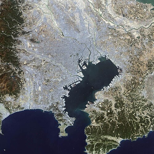
Tokyo Bay (東京湾, Tōkyō-wan) is a bay in the southern Kantō region of Japan. It goes on the coasts of Tokyo, Kanagawa Prefecture, and Chiba Prefecture. The Uraga Channel connects Tokyo Bay to the Pacific Ocean. Its old name was Edo Bay (江戸湾, Edo-wan). The Tokyo Bay region is the place with the most people, and it's the place that is most industrialized in Japan.[1][2][3][4][5]
| Tokyo Bay 東京湾 Tōkyō-wan | |
|---|---|
 Photo of Tokyo Bay (NASA Earth Observatory) | |
 Tokyo Bay, in a narrow sense (pink) and in a broad sense (pink and blue) | |
| Location | Honshu, Japan |
| River sources | Ara River Edo River Obitsu River Yoro River |
| Ocean/sea sources | Pacific Ocean |
| Basin countries | Japan |
| Surface area | 1,500 square kilometres (580 sq mi) |
| Average depth | 40 metres (130 ft) |
| Max. depth | 70 metres (230 ft) |
| Islands | Sarushima |
Tokyo Bay Media
Tokyo Bay and Greater Tokyo at night (2018)
"Tsukuda Takeyo" in Katsushika Hokusai's famous picture collection "Thirty-six Views of Tomitake"*In the latter half of the Edo period, you can see Mt. Fuji far from Tsukuda Island (currently Tsukuda, Chuo-ku, Tokyo) in front of Edo, which is crowded with ships.
American planes over USS Missouri and Tokyo Bay, September 2, 1945
References
- ↑ "Tokyo Bay". Encyclopedia of Japan. Tokyo: Shogakukan. 2012. OCLC 56431036. Archived from the original on 2007-08-25. Retrieved 2012-07-30.
- ↑ "東京湾" [Tokyo Bay]. Dijitaru Daijisen (in 日本語). Tokyo: Shogakukan. 2012. OCLC 56431036. Archived from the original on 2007-08-25. Retrieved 2012-07-30.
- ↑ "東京湾" [Tokyo Bay]. Nihon Kokugo Daijiten (in 日本語). Tokyo: Shogakukan. 2012. OCLC 56431036. Archived from the original on 2007-08-25. Retrieved 2012-07-30.
- ↑ "千葉県:総論 > 東京湾" [Overview of Chiba Prefecture: Tokyo Bay]. Nihon Rekishi Chimei Taikei (in 日本語). Tokyo: Shogakukan. 2012. OCLC 173191044. dlc 2009238904. Archived from the original on 2007-08-25. Retrieved 2012-07-30.
- ↑ "東京湾" [Tokyo Bay]. Nihon Daihyakka Zensho (Nipponika) (in 日本語). Tokyo: Shogakukan. 2012. OCLC 153301537. Archived from the original on 2007-08-25. Retrieved 2012-07-30.
Other websites
| Wikimedia Commons has media related to Lua error in Module:Commons_link at line 62: attempt to index field 'wikibase' (a nil value).. |


