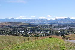
Waiau, Canterbury
Waiau is a small town situated in the Hurunui District, New Zealand. It is located 30 kilometers east of Hanmer Springs and 83 southwest of Kaikōura. It is on the northern bank of the Waiau Uwha River. It has a small store and school. Waiau was impacted by the 2016 Kaikoura earthquake.
town | |
 | |
| Lua error in Module:Infobox_mapframe at line 118: attempt to index field 'wikibase' (a nil value). | |
| Coordinates: 42°39′16″S 173°02′33″E / 42.65444°S 173.04250°ECoordinates: 42°39′16″S 173°02′33″E / 42.65444°S 173.04250°E | |
| Country | New Zealand |
| Region | Canterbury |
| Territorial authority | Hurunui District |
| Ward | West Ward |
| Electorates | |
| Government | |
| • Territorial Authority | Hurunui District Council |
| • Regional council | Environment Canterbury |
| • Mayor of Hurunui | Marie Black |
| • Kaikoura MP | Stuart Smith |
| • Te Tai Tonga MP | Tākuta Ferris |
| Area | |
| • Total | 0.97 km2 (0.37 sq mi) |
| Time zone | UTC+12 (New Zealand Standard Time) |
| • Summer (DST) | UTC+13 (New Zealand Daylight Time) |
| Postcode | 7332 |
Waiau, Canterbury Media
References
- ↑ "ArcGIS Web Application". statsnz.maps.arcgis.com. Retrieved 24 August 2021.
- ↑ "Subnational population estimates (RC, SA2), by age and sex, at 30 June 1996-2022 (2022 boundaries)". Statistics New Zealand. Retrieved 25 October 2022. (regional councils); "Subnational population estimates (TA, SA2), by age and sex, at 30 June 1996-2022 (2022 boundaries)". Statistics New Zealand. Retrieved 25 October 2022. (territorial authorities); "Subnational population estimates (urban rural), by age and sex, at 30 June 1996-2022 (2022 boundaries)". Statistics New Zealand. Retrieved 25 October 2022. (urban areas)

