Wind shear
Wind shear is a difference in either wind speed or direction over a fairly short distance in the atmosphere. Wind shear can be divided into two different types: horizontal and vertical wind shear.

When wind shear is observed
Weather situations when the Wind shear is observed happen:
- At weather fronts when the temperature difference across the front is 5 °C or more, and the front moves at 15 kt or faster.
- At low level jets when a significant low level vertical wind shear can develop near the lower portion of the low level jet.
- At mountains when winds blow over and create vertical shear on the lee side.[1]
- At inversions when on a clear and calm night a radiation inversion is formed near the ground.
- At downbursts when an outflow boundary moves away from a thunderstorm.
- At sailing when wind shear affects sailboats by presenting a different wind speed and direction at different heights along the sailing mast.
Wind Shear Media
Cirrus uncinus ice crystal plumes showing high-level wind shear, with changes in wind speed and direction
Down draft winds with associated virga allow these clouds in the eastern sky at civil twilight to mimic aurora borealis in the Mojave Desert.
Wind shear along the coast with low-level clouds moving towards the east and higher-level clouds moving towards the south-west
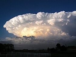
Strong wind shear in the high troposphere forms the anvil-shaped top of this mature cumulonimbus cloud, or thunderstorm.
Wreckage of Delta Air Lines Flight 191 tail section after a microburst slammed the aircraft into the ground. Another aircraft can be seen flying in the background past the crash scene.
Related pages
Notes
- ↑ National Center for Atmospheric Research. T-REX: Catching the Sierra’s waves and rotors Archived 2009-02-21 at the Wayback Machine Retrieved on 2006-10-21.
Other websites
| Wikimedia Commons has media related to Lua error in Module:Commons_link at line 62: attempt to index field 'wikibase' (a nil value).. |
- National Science Digital Library - Wind shear Archived 2005-04-20 at the Wayback Machine


