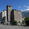
Aosta
Aosta (Italian: [Aosta] Error: {{Lang}}: text has italic markup (help), French: [Aoste] Error: {{Lang}}: text has italic markup (help)) is a city in northern Italy. It is the capital city of the Valle d'Aosta (French: [Vallée d'Aoste] Error: {{Lang}}: text has italic markup (help)) region. It is roughly in the middle of the region, along the Dora Baltea (French: [Doire baltée] Error: {{Lang}}: text has italic markup (help)), the main river that flows in the valley. It is at 583 m above sea level. Around the city there are many mountains (the Alps).
|
Aoûta (Arpitan) | |
|---|---|
| Città di Aosta Ville d'Aoste | |
| 250px | |
Flag of Flag | |
| Country | Italy |
| Region | Aosta Valley |
| Frazioni | Arpuilles, Beauregard, Bibian, Bioulaz, Borgnalle, Brenloz, Busséyaz, Cache, La Combe, Les Capucins, Chabloz, Champailler, Collignon, Cossan, Cotreau, Duvet, Entrebin, Excenex, Les Fourches, Laravoire, Montfleury, Movisod, Pallin, Papet, Pléod, Porossan, La Riondaz, La Rochère, Roppoz, Saraillon, Saumont, Seyssinod, Signayes, Talapé, Tsanté, Tzambarlet, Vignole |
| Government | |
| • Mayor | Fulvio Centoz ([[List of political parties in Italy|PD]]) |
| Area | |
| • Total | 21.37 km2 (8.25 sq mi) |
| Elevation | 583 m (1,913 ft) |
| Population (30 November 2013)[1] | |
| • Total | 34,800 |
| • Density | 1,628.5/km2 (4,218/sq mi) |
| Time zone | UTC+1 (CET) |
| • Summer (DST) | UTC+2 (CEST) |
| Postal code | 11100 |
| Patron saint | St. Gratus |
| Saint day | September 7 |
| Website | Official website |
Romans conquered the area in 25 BC. Later, the city was conquered by the Frankish Empire after the fall of the Western Roman Empire. Finally, it went under control of the House of Savoy in the 11th century. Many Roman buildings still survive in the city, like the east and south gates. The basic plan of the city, with rectangular blocks of streets, is Roman.
History
The valley of Aosta is a typical alpine valley, cut into a V-shape by glaciers during the ice age. It runs from an upper part near Mont Blanc to lower areas like the city of Aosta.
The area has been Roman, French and Italian (House of Savoy) before the unification of Italy. All street names are in French and Italian, and dialects of French are still spoken by many.
Roman Aosta
The Romans defeated the local Salassi tribe in 25 BC.[2] Their commander, Marcus Terentius Varro, then founded the Roman colony of Augusta Praetoria Salassorum, housing 3,000 retired veterans.
After 11 BC Aosta became the capital of the Alpes Graies ("Grey Alps") province of the Empire.
Significance
Aosta is at the join of two rivers. It is at the end of the Great St Bernard Pass (which leads to Switzerland) and the Little St Bernard Pass (which leads to France). Its position gave it considerable military importance, and the layout of the town was that of a Roman military camp.
The valley was a way for trade and soldiers to get from Italy to Gaul (later, France). This explains its importance to the Romans. Now it sits near the Italian entrance of the Mont Blanc Tunnel.
At present Aosta Valley is a semi-autonomous region in northwestern Italy. It is the smallest region in Italy, and is not divided into provinces.
Aostan
Aostan French (French: [français valdôtain] Error: {{Lang}}: text has italic markup (help)) is the variety of French spoken in the Aosta Valley, where many speak some form of French. Some expressions, words and phrase constructions are different from standard French; some are similar to Swiss French. Some words come from the Piedmontese language or Italian. Both modern French and Italian mix with this local patois, valdôtain, which is Franco-Provençal in type.
Aosta Media
- ValleDAostaAug152024.jpg
View of the plaine aostoise and the Monte Emilius
- Aoste - panoramio (15).jpg
- Aostepanoramio()
- Gonfanon Aoste Salon ducal.JPG
The gonfalon of Aosta/Aoste in the salon ducal of the Hôtel-de-Ville
Vue de la façade occidentale de la cathédrale d'Aoste (Vallée d'Aoste, Italie).
References
- ↑ Bilancio demografico Anno 2013 Novembre (dati provvisori). Provincia: Valle d'Aosta/Vallée d'Aoste Archived 2016-03-04 at the Wayback Machine, Istat.
- ↑ Lempriere, John (1839). Bibliotheca Classica: Or, A Dictionary of All the Principal Names and Terms Relating to the Geography, Topography, History, Literature, and Mythology of Antiquity and of the Ancients; with a Chronological Table. W.E. Dean. p. 281.
Other websites
- Official website Archived 2013-04-07 at the Wayback Machine

