Bagnotar
Bagnotar is a Union Council of Abbottabad District in the Khyber Pakhtunkhwa province of Pakistan.[2] Bagnator is on Abbottabad-Nathia Gali Road, 16 Kilometers away from Abbottabad city.
 | |
| Coordinates: 34°7′0″N 73°19′59″E / 34.11667°N 73.33306°ECoordinates: 34°7′0″N 73°19′59″E / 34.11667°N 73.33306°E[1] | |
| Country | Pakistan |
| Province | Khyber Pakhtunkhwa |
| District | Abbottabad |
| Tehsil | Abbottabad |
| Government | |
| • Member District Council | Sardar Saeed Anwer |
| • Member Tehsil Council | Sardar Shuja Ahmed |
| Population | |
| • Total | 13,500 |
Location
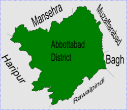
The Union Council Bagnotar is in central part of Abbottabad District in south-east of Abbottabad city[1] - capital city of the district. Bagnotar is next to following union councils, to the north by Sarbhana, to the east and to the south by Namli Maira, and to the west by Bagh.
Subdivisions
Union Council Bagnotar is divided into three subdivisions:
- Village Council Bagnotar
Chairman Sardar Muhammad Dilnawaz.
- Village Council Bandi Maira
Chairman Muhammad Jamil Abbasi.
- Village Council Chahan
Chairman Malik Iqbal Awan.
District Council Member: Sardar Saeed Anwar.
Tehsil Council Member: Sardar Shuja Ahmed.
updated by Muhammad Sajjad Jadoon Bagnotar.
Schools in Bagnotar
Village Council Bagnotar
- Government Boys Higher Secondary School Bagnotar
- Government Girls High School Bagnotar
- Government Primary School Bagnotar
- Government Primary School Khurri Banda Bagnotar
- Government Primary School Gulaga Bagnotar
- Government Primary School Seri, Bagnotar
- Government Primary School Gaiya Bagnotar
Village Council Bandi Maira
- Government Primary School Riyan Tareeda
Village Council Chahan
- Government Primary School Chahan, Bandi Maira
Vegetation
The vegetation in Bagnotar is naturally grown. Both coniferous and deciduous species are present on a large area of the whole union council. The notable species are Pinus wallichiana, Pinus roxburghii, Cedrus deodara, Taxus baccata, Diospyrus lotus, Salix tetrasperma, Quercus dilatata, Morus elba, Aesculus indica.
References
- ↑ 1.0 1.1 Falling Rain: Location of Bagnotar[dead link]
- ↑ Lua error in Module:Citation/CS1/Utilities at line 38: bad argument #1 to 'ipairs' (table expected, got nil).