Cape Hatteras

Cape Hatteras is a cape on the coast of North Carolina. It is the point that protrudes the farthest to the southeast along the northeast-to-southwest line of the Atlantic coast of North America, making it a key point for navigation along the eastern seaboard. So many ships have been lost around it that the area is known as the "Graveyard of the Atlantic". The nearby shoals are known as Diamond Shoals.
The Cape Hatteras Lighthouse is a well known feature on Cape Hatteras. It was built in 1870 and it is the tallest brick lighthouse in the United States.
Climate
| Climate data for Cape Hatteras (Billy Mitchell Airport), 1981–2010 normals, extremes 1898–present[a] | |||||||||||||
|---|---|---|---|---|---|---|---|---|---|---|---|---|---|
| Month | Jan | Feb | Mar | Apr | May | Jun | Jul | Aug | Sep | Oct | Nov | Dec | Year |
| Record high °F (°C) | 75 (23.9) |
76 (24.4) |
82 (27.8) |
89 (31.7) |
91 (32.8) |
97 (36.1) |
96 (35.6) |
94 (34.4) |
92 (33.3) |
89 (31.7) |
81 (27.2) |
78 (25.6) |
97 (36.1) |
| Average high °F (°C) | 52.2 (11.22) |
53.5 (11.94) |
58.6 (14.78) |
66.3 (19.06) |
73.7 (23.17) |
81.0 (27.22) |
84.6 (29.22) |
84.1 (28.94) |
79.9 (26.61) |
72.0 (22.22) |
64.0 (17.78) |
55.9 (13.28) |
68.9 (20.5) |
| Average low °F (°C) | 38.7 (3.72) |
40.0 (4.44) |
44.6 (7) |
52.6 (11.44) |
60.5 (15.83) |
69.3 (20.72) |
73.6 (23.11) |
72.9 (22.72) |
69.0 (20.56) |
59.7 (15.39) |
51.2 (10.67) |
42.7 (5.94) |
56.3 (13.5) |
| Record low °F (°C) | 6 (-14.4) |
11 (-11.7) |
19 (-7.2) |
26 (-3.3) |
39 (3.9) |
44 (6.7) |
52 (11.1) |
56 (13.3) |
45 (7.2) |
32 (0) |
22 (-5.6) |
12 (-11.1) |
6 (-14.4) |
| Precipitation inches (mm) | 5.24 (133.1) |
4.02 (102.1) |
4.77 (121.2) |
3.64 (92.5) |
3.57 (90.7) |
4.03 (102.4) |
4.99 (126.7) |
6.93 (176) |
6.25 (158.8) |
5.38 (136.7) |
4.95 (125.7) |
4.27 (108.5) |
58.04 (1,474.2) |
| Snowfall inches (cm) | 0.3 (0.8) |
0.1 (0.3) |
0 (0) |
0 (0) |
0 (0) |
0 (0) |
0 (0) |
0 (0) |
0 (0) |
0 (0) |
0 (0) |
1.3 (3.3) |
1.7 (4.3) |
| % Humidity | 75.3 | 74.3 | 74.1 | 72.3 | 77.3 | 79.0 | 80.9 | 80.6 | 78.5 | 75.8 | 75.1 | 75.1 | 76.5 |
| Avg. precipitation days (≥ 0.01 in) | 10.6 | 10.5 | 10.3 | 8.8 | 8.8 | 10.1 | 11.6 | 11.2 | 9.6 | 8.9 | 9.6 | 10.4 | 120.4 |
| Avg. snowy days (≥ 0.1 in) | 0.4 | 0.3 | 0 | 0 | 0 | 0 | 0 | 0 | 0 | 0 | 0 | 0.3 | 1.0 |
| Sunshine hours | 153.7 | 162.8 | 224.8 | 261.3 | 278.3 | 272.4 | 282.9 | 267.1 | 233.0 | 207.2 | 170.8 | 142.8 | 2,657.1 |
| Source: NOAA (relative humidity and sun 1961–1990)[1][2][3] | |||||||||||||
Notes and references
Cape Hatteras Media
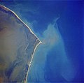
Cape Hatteras from space, October 1989. Image orientated with North to the left and East pointing up.

An aerial view of where Hurricane Isabel cut inlets into Hatteras Island

Climate chart for Cape Hatteras

The Cape Hatteras Life Guard Station, which later became part of the Durant Motel, and was upended by Hurricane Isabel in 2003


_-_Cape_Hatteras_Area,NC_(ThreadEx).svg)

Notes
References
- ↑ 1.0 1.1 "NOWData - NOAA Online Weather Data". National Oceanic and Atmospheric Administration. Retrieved 2016-09-07.
- ↑ "Station Name: NC CAPE HATTERAS AP". National Oceanic and Atmospheric Administration. Retrieved 2016-09-07.
- ↑ "WMO Climate Normals for CAPE HATTERAS, NC 1961–1990". National Oceanic and Atmospheric Administration. Retrieved 2014-05-27.
Other websites
| Wikimedia Commons has media related to Lua error in Module:Commons_link at line 62: attempt to index field 'wikibase' (a nil value).. |
Coordinates: 35°15′16″N 75°31′12″W / 35.25458°N 75.51995°W