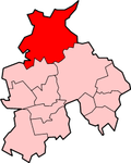
City of Lancaster
| City of Lancaster | |
|---|---|
 Shown within Lancashire | |
| Geography | |
| Status: | City (1937) |
| Region: | North West England |
| Admin. County: | Lancashire |
| Area: - Total |
Ranked 85th 575.86 km² |
| Admin. HQ: | Lancaster |
| ONS code: | 30UH |
| Demographics | |
| Population: - Total (2005 est.) - Density |
Ranked 129th 138,000 240 / km² |
| Ethnicity: | 95.5% All White 2.5% All Asian 0.9% All Mixed 0.5% All Black 0.5% All Other |
| Politics | |
| Leadership: | Leader & Cabinet |
| Executive: | Labour / Liberal Democrats / Green |
| MPs: | Ben Wallace, Geraldine Smith |
The City of Lancaster (2002 population: 133,914) is a local government district in Lancashire, England. Its main town is Lancaster, from which it obtained its city status. Other towns in the district include Morecambe, Heysham, Slyne, and Carnforth.
History
The district was made on April 1 1974, under the Local Government Act 1972, when the boroughs of Lancaster and Morecambe and Heysham, along with Carnforth urban district, Lancaster Rural District and Lunesdale Rural District joined together.
Population
| Ethnic Group | City of Lancaster | North West | England |
|---|---|---|---|
| White British | 95.5% | 92.9% | 89.1% |
| White Irish | 0.8% | 1.1% | 1.2% |
| Other White | 2.7% | 1.5% | 3.2% |
| Mixed White and Black | 0.4% | 0.6% | 0.7% |
| Mixed White and Asian | 0.3% | 0.3% | 0.5% |
| Other Mixed | 0.2% | 0.3% | 0.4% |
| Indian | 0.9% | 1.3% | 2.4% |
| Pakistani | 0.4% | 2.0% | 1.6% |
| Bangladeshi | 0.2% | 0.5% | 0.6% |
| Other Asian | 0.2% | 0.3% | 0.6% |
| Black Caribbean | 0.2% | 0.4% | 1.2% |
| Black African | 0.3% | 0.5% | 1.3% |
| Black Other | 0.0% | 0.1% | 0.2% |
| Chinese | 0.9% | 0.6% | 0.7% |
| Other Ethnic Group | 0.5% | 0.3% | 0.6% |
Twin Cities
City Of Lancaster Media
Town Hall, Dalton Square, Lancaster


