Elkader, Iowa
Elkader is a city in Iowa in the United States.
 | |
|
| |
 Location of Elkader, Iowa | |
| Coordinates: 42°51′21″N 91°24′11″W / 42.85583°N 91.40306°WCoordinates: 42°51′21″N 91°24′11″W / 42.85583°N 91.40306°W | |
| Country | |
| State | |
| County | Clayton |
| Area | |
| • Total | 1.37 sq mi (3.54 km2) |
| • Land | 1.37 sq mi (3.54 km2) |
| • Water | 0.00 sq mi (0.00 km2) |
| Elevation | 732 ft (223 m) |
| Population (2020) | |
| • Total | 1,209 |
| • Density | 884.42/sq mi (341.39/km2) |
| Time zone | UTC-6 (Central (CST)) |
| • Summer (DST) | UTC-5 (CDT) |
| ZIP code | 52043 |
| FIPS code | 19-24690 |
| GNIS feature ID | 0456303 |
| Website | elkader-iowa |
Population
| Historical population | ||
|---|---|---|
| Year | Population | ±% |
| 1860 | 440 | — |
| 1870 | 697 | +58.4% |
| 1880 | 851 | +22.1% |
| 1890 | 745 | −12.5% |
| 1900 | 1,321 | +77.3% |
| 1910 | 1,181 | −10.6% |
| 1920 | 1,223 | +3.6% |
| 1930 | 1,382 | +13.0% |
| 1940 | 1,556 | +12.6% |
| 1950 | 1,584 | +1.8% |
| 1960 | 1,526 | −3.7% |
| 1970 | 1,592 | +4.3% |
| 1980 | 1,688 | +6.0% |
| 1990 | 1,510 | −10.5% |
| 2000 | 1,465 | −3.0% |
| 2010 | 1,273 | −13.1% |
| 2020 | 1,209 | −5.0% |
| Source: "U.S. Census website". United States Census Bureau. Retrieved 2020-03-28. Source: | ||
Elkader, Iowa Media
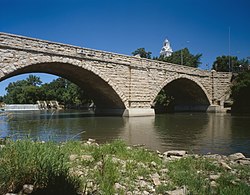
Elkader Keystone Bridge is listed on the NRHP
References
- ↑ "2020 U.S. Gazetteer Files". United States Census Bureau. Retrieved March 16, 2022.
- ↑ "Census of Population and Housing". Census.gov. Retrieved June 4, 2015.
- ↑ "2020 Census State Redistricting Data". census.gov. United states Census Bureau. Retrieved 12 August 2021.


