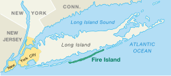
Fire Island, New York
Fire Island is a barrier island, approximately 31 miles (49.5 km) long and varying between approximately 0.1 mile (0.16 km) to 0.5 mile (0.8 km) wide, in Suffolk County on the southern side of Long Island in the U.S. state of New York, running approximately WSW to ENE. The land area is 48 km² (18.7 sq mi) and a permanent population of 310 persons was reported as of the 2000 census. (There are many thousands of seasonal residents.)
 Fire Island | |
| Coordinates: Coordinates: 40°39′11″N 73°7′33″W / 40.65306°N 73.12583°W | |
| Country | United States |
| State | New York |
| County | Suffolk |
| Area | |
| • Total | 8.7 sq mi (22.4 km2) |
| • Land | 8.7 sq mi (22.4 km2) |
| • Water | 0.0 sq mi (0.0 km2) |
| Elevation | 3 ft (1 m) |
| Population (2000) | |
| • Total | 310 |
| • Density | 35.8/sq mi (13.8/km2) |
| Time zone | UTC-5 (Eastern (EST)) |
| • Summer (DST) | UTC-4 (EDT) |
| ZIP code | 11770 |
| FIPS code | 36-25839 |
| GNIS feature ID | 1852899 |
The Cherry Grove and Fire Island Pines hamlets of Fire Island have been known as a popular gay village.[1]
Fire Island, New York Media
Fire Island Lighthouse, east of Robert Moses field 5
German full-rigged ship Peter Rickmers aground on Fire Island, April 30, 1908
The world's first true tanker, the Glückauf, stranded on March 23/24, 1893 in heavy fog at Blue Point Beach on Fire Island
References
- ↑ "Fire Island: A gay paradise of sex and liberation". BBC. Retrieved July 23, 2023.
Other websites
| 40x40px | Wikimedia Commons has media related to Lua error in Module:Commons_link at line 62: attempt to index field 'wikibase' (a nil value).. |
| Wikivoyage has a travel guide about: Fire Island |


