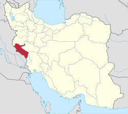
Ilam province
(Redirected from Ilam Province)
Ilam Province (Persian: استان ایلام, Kurdish: [Parêzgeha Îlamê ,پارێزگای ئیلام] Error: {{Lang}}: text has italic markup (help)) is one of the 31 provinces of Iran. Its capital is Ilam.
|
استان ایلام | |
|---|---|
| Etymology: The ancient pre-Iranic civilization of Elam | |
|
| |
 Location of Ilam within Iran | |
| Coordinates: 33°38′18″N 46°25′21″E / 33.6384°N 46.4226°ECoordinates: 33°38′18″N 46°25′21″E / 33.6384°N 46.4226°E | |
| Country | |
| Region | Region 4 |
| Founded | 1974 |
| Capital | Ilam |
| Counties | List
|
| Government | |
| • Body | Provincial Government |
| • Governor-general | Qasem Soleimani Dashtaki (Reformist) |
| Area | |
| • Province | 20,164.11 km2 (7,785.41 sq mi) |
| • Urban | 30.13 km2 (11.63 sq mi) |
| • Rank | 22nd |
| Latest measurement in 2019 | |
| Highest elevation [4] (Kan Seifi Peak) | 2,775 m (9,104 ft) |
| Lowest elevation | 36 m (118 ft) |
| Population (2016)[1] | |
| • Province | 580,158 |
| • Estimate (2020)[6] | 602,000 |
| • Rank | 31st (last) |
| • Density | 28.77181/km2 (74.51865/sq mi) |
| • Urban | 395,263 |
| • Rural | 184,444 |
| Time zone | UTC+03:30 (IRST) |
| • Summer (DST) | UTC+04:30 (IRST) |
| Postal code | 69311–69991[7] |
| Vehicle registration | Iran 98[8] |
| HDI (2017) | 0.815[9] very high · 8th |
| Website | Ilam Portal |
Ilam Province Media
Buyids rule over western Iran
Siah-Ghav Twin Lakes, near Abdanan
Persian turpentine tree
Persian oak forest in Ilam province
References
- ↑ 1.0 1.1 سالنامه آماری کشور سال ۱۳۹۷ [Statistical Yearbook of Iran Year 1397] (in فارسی). Tehran, Iran: مرکز آمار ایران. 2019. Archived from the original on 2016-03-01. Retrieved 2020-06-12.
- ↑ 2.0 2.1 2.2 السادات حائری, زهرا (2019). سالنامه آماری استان ایلام سال ۱۳۹۷ [Statistical Yearbook of Ilam Province in 1397] (in فارسی). Ilam, Iran: سازمان مدیریت و برنامهریزی استان ایلام. Archived from the original on 2020-06-08. Retrieved 2020-06-13.
- ↑ "هواشناسی ایلام". www.ilammet.ir. Retrieved 2020-06-08.
- ↑ (in fa). Ilam Press. January 10, 2015. http://www.ilampress.com/news/sports/%DA%A9%D8%A7%D9%86-%D8%B5%DB%8C%D9%81%DB%8C/. Retrieved 17 September 2015.[dead link]
- ↑ Google Earth Pro V 7.1.5.1557. Mehran County, Iran. 32° 58’ 53.80”N, 46° 05’ 47.61”E, Eye alt 1760 meters: US Dept of State Geographer. Google 2015. Cnes/Spot Image 2015. December 22, 2002. Archived from the original on September 8, 2010. Retrieved September 18, 2015.
{{cite book}}: CS1 maint: location (link) - ↑ "پيشبينی جمعيت كل كشور به تفكيك استان و مناطق شهری و روستايی و برحسب جنس از سال ۱۳۹۶ تا ۱۴۱۵" [Predicting the total population of the country by province and urban and rural areas and by gender from 1396 to 1415 SH]. Statistical Center of Iran (Microsoft Excel). Statistical Center of Iran. 2018-05-28. Archived from the original on 2018-11-16. Retrieved 2020-06-12.
- ↑ کدپستی ۵ رقمی مناطق استان ایلام. سامانه پیامک برتر (in فارسی). سامانه پیامک برتر. Archived from the original on 31 August 2015. Retrieved 18 September 2015.
- ↑ راهنمای کامل شماره پلاک خودرو به تفکیک شهر و استان. Setareh (in فارسی). مجله اینترنتی ستاره. May 17, 2015. Retrieved 17 September 2015.
- ↑ "Sub-national HDI - Area Database - Global Data Lab". hdi.globaldatalab.org. Retrieved 2018-09-13.


