Interstate 70
Interstate 70 is a major interstate highway in the United States. It begins in Cove Fort, Utah, and it goes east to Baltimore, Maryland. The route is 2,153.13 miles (3,465.13 km) long and travels through 10 states.[1] It also goes through some major cities in the heart of America including Denver, Kansas City, St. Louis, Indianapolis, and Columbus.
| Lua error in Module:Infobox_road/route at line 107: bad argument #1 to 'wikitext' (string or number expected, got boolean). | |
|---|---|
| Route information | |
| Length | 2,151.43 mi[1] (3,462.39 km) |
| Existed | 1956–present |
| History | Completed in 1992 |
| Major junctions | |
| West end | Lua error in Module:Jct at line 204: attempt to concatenate local 'link' (a boolean value). near Cove Fort, UT |
| |
| East end | Lua error in package.lua at line 80: module 'Module:Road data/extra' not found. Park and Ride lot in Baltimore, MD |
| Lua error in package.lua at line 80: module 'Module:Road data/size' not found. | |
| Highway system | |
Interstate 70 Media
I-70 passes through Spotted Wolf Canyon at the eastern edge of the San Rafael Swell in Utah.
I-70 at Glenwood Canyon
I-70 at the portal of the Eisenhower Tunnel. The traffic signal is controlled from a command center and used for incident management.
I-70 as it turns north at Copper Mountain, approximately 2.5 miles (4.0 km) from Vail Pass
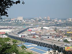
I-70 crossing on the Intercity Viaduct over the Kansas River from Kansas to Missouri in Kansas City
I-70 in Saline County, Missouri
I-70 near its junction with I-65, east of Downtown Indianapolis, Indiana
Crossing the Ohio River (Fort Henry Bridge) at Wheeling, West Virginia
I-70/I-76 at the Allegheny Mountain Tunnel
References
- ↑ 1.0 1.1 Adderly, Kevin (January 15, 2014). "Table 1: Main Routes of the Dwight D. Eisenhower National System of Interstate and Defense Highways as of December 31, 2014". Route Log and Finder List. Federal Highway Administration. Retrieved February 6, 2015.
Lua error in Module:Attached_KML at line 224: attempt to index field 'wikibase' (a nil value).


