Interstate 87 (New York)
Interstate 87 is an Interstate Highway in the state of New York in the United States. It goes from New York City north to Champlain at the Canada border where it connects to Autoroute 15. The route is 333.49 miles (536.70 km) long.[1] The southern half of the interstate (between NYC and Albany) is part of the New York State Thruway (tollway). North of Albany, the highway is called the Adirondack Northway. It is also part of I-287 in Westchester County, from exits 8-15. Its short length through the NYC borough of the Bronx is called the Major Deegan Expressway.
| Lua error in Module:Infobox_road/route at line 107: bad argument #1 to 'wikitext' (string or number expected, got boolean). | ||||
|---|---|---|---|---|
Map of the northeastern United States with I-87 highlighted in red | ||||
| Route information | ||||
| Maintained by NYSTA and NYSDOT | ||||
| Length | 333.49 mi (536.70 km) | |||
| Existed | August 14, 1957–present | |||
| Restrictions | No explosives (including in cargo) between exits 11 and 9 on the NYST. | |||
| Major junctions | ||||
| South end | Lua error in Module:Jct at line 204: attempt to concatenate local 'link' (a boolean value). in The Bronx | |||
| ||||
| North end | Lua error in Module:Jct at line 204: attempt to concatenate local 'link' (a boolean value). at the Canadian border in Champlain | |||
| Lua error in package.lua at line 80: module 'Module:Road data/size' not found. | ||||
| Highway system | ||||
| ||||
| ||||
Interstate 87 (New York) Media
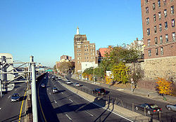
The Deegan in the West Bronx
The Deegan passing by the Bronx Terminal Market
Looking east along I-87/I-287 (the Thruway) toward the Tappan Zee Bridge from Nordkop Mountain in Suffern
The Thaddeus Kosciusko Bridge carries I-87 (the Northway) over the Mohawk River north of Albany.
View to High Peaks region from the northbound side of the Northway in Schroon Lake
Bilingual sign for exit 34 (NY 9N) in Keeseville
References
Lua error in Module:Attached_KML at line 224: attempt to index field 'wikibase' (a nil value).


