Lake Zug
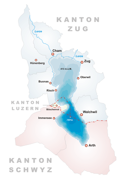
The Lake Zug (German: Zugersee) is one of the lesser known Swiss lakes, on the outskirts of the Alps and north of Lake Lucerne. It is fed by the Aa, which descends from the Rigi and enters the south end of the lake. The Lorze feeds the lake at the northern shore.
| Lake Zug Zugersee | |
|---|---|
| | |
| Coordinates | 47°7′N 8°29′E / 47.117°N 8.483°E |
| Primary inflows | Lorze |
| Primary outflows | Lorze |
| Catchment area | 204 km² (79 mi²) |
| Basin countries | Switzerland |
| Max. length | 13.8 km (8.6 mi) |
| Max. width | 4.7 km (2.9 mi) |
| Surface area | 38.3 km² (15 mi²) |
| Average depth | 83.2 m (293 ft) |
| Max. depth | 198 m (650 ft) |
| Water volume | 3.2 km³ |
| Residence time | 14.7 years |
| Surface elevation | 417 m (1,368 ft) |
| Settlements | see list |
For the most part, the lake is in the Canton of Zug, but the southern end is up to 10 km in the canton of Schwyz, while the Canton of Lucerne stretches over a 2 km area by the Immensee.
At its northern end the shores are nearly level, while on the west shore the wooded promontory of Buonas (with its castles, old and new) projects picturesquely into the waters. The principal place on the lake is the town of Zug. Three railways follow the shore of the lake, one from Zürich via Zug and Arth-Goldau to the St Gotthard, one from Lucerne via Arth-Goldau to the St Gotthard and one from Zürich via Zug to Lucerne.
Many fish (including pike and carp of considerable weights) are taken from the lake, which is especially famous for an endemic kind of trout (Salmo salvelinus, locally called Rolheli). Because of farming runoff, it is not one of Switzerland's cleanest lakes.
List of cities and places on the lake
Historical notes
In 1911, a railway was built around the lake.
Lake Zug Media
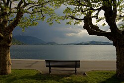
Lake Zug with view of Rigi
Other websites
- Waterlevels of Lake Zug Archived 2007-06-14 at the Wayback Machine at Zug
| Wikimedia Commons has media related to Lua error in Module:Commons_link at line 62: attempt to index field 'wikibase' (a nil value).. |


