Los Alamos, New Mexico
Los Alamos (Spanish: Los Álamos, meaning "The Cottonwoods" or "The Poplars")[3] is a town in Los Alamos County, New Mexico, United States. The town is located on four mesas of the Pajarito Plateau, and has a population of 13,179.[2] It is the county seat and one of two population centers in the county known as census-designated places (CDPs); the other is White Rock.
 | |
|
| |
|
| |
 Location of Los Alamos, New Mexico | |
| Coordinates: 35°53′28″N 106°17′52″W / 35.89111°N 106.29778°WCoordinates: 35°53′28″N 106°17′52″W / 35.89111°N 106.29778°W | |
| Country | |
| State | |
| County | Los Alamos |
| Area | |
| • Total | 11.11 sq mi (28.77 km2) |
| • Land | 11.11 sq mi (28.77 km2) |
| • Water | 0.00 sq mi (0.00 km2) |
| Elevation | 7,320 ft (2,231 m) |
| Population | |
| • Total | 13,179 |
| • Density | 1,186.44/sq mi (458.09/km2) |
| Time zone | UTC−7 (Mountain (MST)) |
| • Summer (DST) | UTC−6 (MDT) |
| ZIP codes | 87544, 87547 |
| FIPS code | 35-42320 |
| GNIS feature ID | 0901357 |
Los Alamos, New Mexico Media

The entrance to Los Alamos was guarded at the Main Gate during the Manhattan Project.
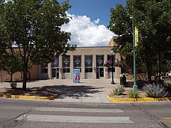
Los Alamos post office, built in 1948

Aftermath of the Cerro Grande Fire of 2000

J. Robert Oppenheimer, c. 1944


.jpg)
References
- ↑ "ArcGIS REST Services Directory". United States Census Bureau. Retrieved October 12, 2022.
- ↑ 2.0 2.1 "QuickFacts: Los Alamos CDP, New Mexico". United States Census Bureau. Retrieved March 14, 2024.
- ↑ Julyan, Robert Hixson (1998), The Place Names of New Mexico, Albuquerque: University of New Mexico Press, p. 208, ISBN 978-08263-1689-9