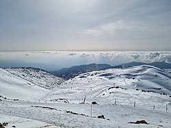
Mount Hermon
Mount Hermon (Arabic: جبل الشيخ, Jabal al-Shaykh, "Mountain of the Chief"; Hebrew: הר חרמון, Har Hermon, "Mount Hermon") is a very high mountain cluster in the Eastern Lebanon Mountain Range. Its summit sits on the border between Syria, Lebanon, and the Israeli-occupied Golan Heights.[1] At 2,814 metres (9,232 ft) above sea level, it is the highest point in Syria and Israel.[2] The southern slopes of Mount Hermon extend into the Israeli part of the Golan Heights. Most of the mountain peaks are snowy in the winter. Mount Hermon has the highest precipitation in Syria.
 Mount Hermon, viewed from Mount Bental in the Golan Heights | |
| Elevation | 2,814 m (9,232 ft) |
|---|---|
| Prominence | 1,804 m (5,919 ft) |
| Listing | Country high point Ultra |
| Location | |
| Location | Syria, Lebanon, Israel |
| Range | Anti-Lebanon mountain range |
Mount Hermon Media
Roman temple of Qasr el Banat, Lebanon
Mount Hermon and Lake Qaraoun
A spring in the Hermon
Israeli soldiers after the recapture of their outpost in the Syrian part of Mount Hermon, October 1973
The Mount Hermon ski resort on the syrian slopes of the mountain, annexed by Israel
References
- ↑ ACME Mapper terrain display
- ↑ "CIA World Fact Book: Syria". 14 November 2011. Archived from the original on 29 December 2017. Retrieved 27 November 2011.
highest point: Mount Hermon 2,814 m
Other websites
![]() Media related to Mount Hermon at Wikimedia Commons
Media related to Mount Hermon at Wikimedia Commons
- Photos of Mount Hermon ski resort (in a snowless season) Archived 2016-04-11 at the Wayback Machine
- Israeli Hermon sky resort Archived 2013-03-14 at the Wayback Machine


