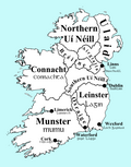
Provinces of Ireland
| The Four Provinces of Ireland Ceithre Chúigí na hÉireann | |

| |
|---|---|
| Location | |
| 1. Leinster, 2. Munster, 3. Connacht, 4. Ulster | |
| Statistics | |
| Area: | 84,412 km² |
| Population (2006): | 5,962,110 |
The Provinces of Ireland were the main divisions of Ireland prior to 1922 when it was partitioned as a result of the majority of it becoming independent. Ireland was divided into four different provinces, or territorial divisions.
The four provinces are:
| Province | Population (2006) | Area (km²) | Number of Counties† | Chief city |
|---|---|---|---|---|
| 2,292,939 | 19,774 | 12 | Dublin | |
| 1,172,170 | 24,608 | 6 | Cork | |
| 503,083 | 17,713 | 5 | Galway | |
| 1,993,918‡ | 24,481 | 9 | Belfast | |
| † "Number of Counties" is traditional counties, not administrative ones. | ||||

Euler diagram of the countries and traditional provinces on the island of Ireland
Provinces Of Ireland Media
Johann Homann's 1716 map of Ireland. He incorrectly places County Clare in Connacht; it had actually been returned to Munster in the immediate years after 1660.
"Cuchulain in Battle", illustration by J. C. Leyendecker in T. W. Rolleston's Myths & Legends of the Celtic Race, 1911


