Sherwan
Sherwan is a Union Council of Abbottabad District in the Khyber Pakhtunkhwa province of Pakistan.[2] It is 35 kilometres (22 miles) west of the city of Abbottabad.
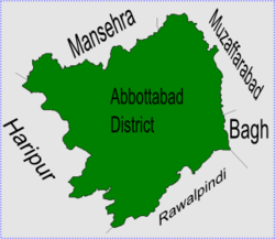
 Sherwan is in Abbottabad District | |
| Coordinates: 34°N 73°E / 34°N 73°ECoordinates: 34°N 73°E / 34°N 73°E | |
| Country | Pakistan |
| Province | Khyber Pakhtunkhwa |
| District | Abbottabad |
| Tehsil | Lower Tanawal |
| Government | |
| • Nazim | Junaid Ahmed[1] |
| • Naib Nazim | Muhammad Kahlid[1] |
| Population | |
| • Total | 15,000 |
People
Over 15,000 people live in Sherwan.[3] The local language is Hindko. Urdu is also understood and spoken by local peoples. The main tribes of this area are the Tanolis and the Awans.
Location
Sherwan is in a beautiful valley which is surrounded by large, forested mountains on three sides. Wild animals live in these forests, such as jackals, wolves, pigs, porcupines and sometimes tigers. Sherwan is divided into two parts: Sherwan Khurd (small) and Sherwan Kalan (wide). Sherwan Kalan covers a much larger area than Sherwan Khurd. In the northeast of Sherwan Union Council there is another place called Patheel.
Subdivisions
The Union Council of Sherwan is subdivided into the following areas: Beri, Kharperh, Thethi Ahmed Khan, Chakar Bain, Chorgran, Juna, Kamila, Kangar Palan, Sherwan Kalan, Sherwan Khurd, Khalabat, Chamhati, Kumharan (Amirabad), Thorey, Kalar Khaitar, Bamochi, Bhateel and Shaheedabad(Cheera).[1]
References
- ↑ 1.0 1.1 1.2 Sherwan Union Council[dead link]
- ↑ "Administrative Units of District Abbottabad". Archived from the original on 2007-04-03. Retrieved 2008-08-01.
- ↑ "List of Union Councils and population in Abbottabad District". Archived from the original on 2007-06-27. Retrieved 2008-08-01.