Sino-Indian border dispute
The Sino-Indian border dispute is about several territories that are claimed by both the People's Republic of China and the Republic of India. The farthest west, Aksai Chin, is part of another dispute involving Pakistan. It is controlled by China but is claimed by the Government of India. They consider it part of the region of Xinjiang. It is a place where very few people live. The other large disputed territory is to the east. It is south of the McMahon Line. It used to be called the North East Frontier Agency. It is now called South Tibet. The McMahon Line was part of the 1914 Simla Convention between British India and Tibet. China rejected the agreement.[1]
Disputes along the Himalayan border
Former Kingdom of Sikkim
In 1975 India annexed the territory of Sikkim. This was rejected by China. Today, the Sikkim-China border's most northern point, "The Finger", is still disputed.[2]
See also
Sino-Indian Border Dispute Media
The western portion of the Line of Actual Control, separating the Eastern Ladakh and Aksai Chin. In the southern Demchok region, only two claim lines are shown (map by the CIA).
Map of Central Asia (1878) showing Khotan (near top right corner). The previous border claimed by the British Indian Empire is shown in the two-toned purple and pink band with Shahidulla and the Kilik, Kilian and Sanju Passes clearly north of the border.
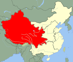
Western Theater Command of China, area under integrated command.
References
- ↑ Calvin, James Barnard (April 1984). "The China-India Border War". Marine Corps Command and Staff College. Retrieved 14 October 2011.
- ↑ Sudha Ramachandran, "China toys with India's border Archived 2009-11-22 at the Stanford Web Archive", Asia Times Online, 27 June 2008.


