Stratford, New Zealand
Stratford (Māori: [Whakaahurangi] Error: {{Lang}}: text has italic markup (help)) is the only town in Stratford District, and the seat of the Taranaki Region, in New Zealand's North Island. The town has a population of 5,740, making it the 62nd largest urban area in New Zealand.[3]
|
Whakaahurangi (Māori) | |
|---|---|
 | |
| Lua error in Module:Infobox_mapframe at line 118: attempt to index field 'wikibase' (a nil value). | |
| Coordinates: 39°20′S 174°17′E / 39.333°S 174.283°ECoordinates: 39°20′S 174°17′E / 39.333°S 174.283°E | |
| Country | |
| Region | Taranaki |
| Territorial authority | Stratford District |
| Ward | Urban |
| Government | |
| • Mayor | Neil Volzke |
| Area | |
| • Minor urban area | 8.54 km2 (3.30 sq mi) |
| • District | 2,163.42 km2 (835.30 sq mi) |
| Elevation | 310 m (1,020 ft) |
| Population (June 2022)[2] | |
| • Urban | 6,130 |
| • District | 10,150 |
| • District density | 4.6916/km2 (12.151/sq mi) |
| Postcode | 4332 |
Stratford, New Zealand Media
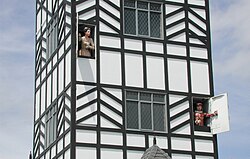
Stratford clock tower "glockenspiel"

References
- ↑ "ArcGIS Web Application". statsnz.maps.arcgis.com. Retrieved 28 February 2021.
- ↑ "Subnational population estimates (RC, SA2), by age and sex, at 30 June 1996-2022 (2022 boundaries)". Statistics New Zealand. Retrieved 25 October 2022. (regional councils); "Subnational population estimates (TA, SA2), by age and sex, at 30 June 1996-2022 (2022 boundaries)". Statistics New Zealand. Retrieved 25 October 2022. (territorial authorities); "Subnational population estimates (urban rural), by age and sex, at 30 June 1996-2022 (2022 boundaries)". Statistics New Zealand. Retrieved 25 October 2022. (urban areas)
- ↑ "Stratford in the Encyclopaedia of New Zealand". Archived from the original on 2020-09-23. Retrieved 2020-09-07.