Supercell
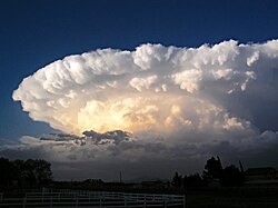
A supercell is a strong type of thunderstorm with a thick, rotating updraft (a mesocyclone).[1] Supercell thunderstorms are the largest, most dangerous type of thunderstorms. There are really only two types of thunderstorms: supercell and ordinary, but some have four classifications: single-cell, multi-cell, squall line, and supercell.
Supercell Media
- A drone photograph of a supercell from Chamberlain, South Dakota in 2023.jpg
A drone photograph of a supercell from Chamberlain, South Dakota on July 18, 2023.
- Supercell hail core near Stratford, Texas on May 18, 2023.jpg
A supercell with a hail core near Stratford, Texas on May 18, 2023.
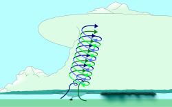
Wind shear (red) sets air spinning (green)
The updraft (blue) 'bends' the spinning air upwards
Structure of a supercell. Northwestward view in the Northern Hemisphere
References
- ↑ "12B". Archived from the original on 2013-07-30. Retrieved 2007-09-25.
- Structure and Dynamics of Supercell Thunderstorms - NWS
- University of Illinois World Weather Project
- Weather Glossary for Storm Spotters - NWS
- Lemon, Leslie R. (1998): On the Mesocyclone "Dry Intrusion" and Tornadogenesis[1] Archived 2013-07-30 at the Wayback Machine
- Lemon, Leslie R., Charles A. Doswell III (1979): "Severe Thunderstorm Evolution and Mesocyclone Structure as Related to Tornadogenesis". Monthly Weather Review Vol. 107, No. 9, pp. 1184–1197.[2] Archived 2006-12-29 at the Wayback Machine
- Browning, K.A. and Ludlam, F.H. (1962): "Airflow In Convective Storms", Quarterly Journal of the Royal Meteorological Society 88, 117-135.[3] Archived 2012-03-07 at the Wayback Machine (PDF)
Other websites
| Wikimedia Commons has media related to Lua error in Module:Commons_link at line 62: attempt to index field 'wikibase' (a nil value).. |
- Electronic Journal of Severe Storms Meteorology
- Explanation of Supercells Archived 2007-09-28 at the Wayback Machine
- Picture sequence of a supercell in Nebraska Archived 2007-10-26 at the Wayback Machine
- Sideshow of Supercell images


