Mesocyclone

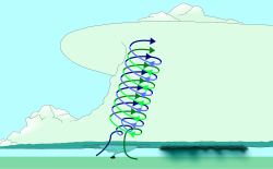
A mesocyclone is a vortex of air, about 2 to 10 km in diameter (the mesoscale of meteorology), inside a convective storm.[1] That is, it is air that rises and rotates around a vertical axis, usually in the same direction as low pressure systems in a given hemisphere. They are most often cyclonic, that is, related with a localized low pressure area inside a severe thunderstorm. Such storms can create strong surface winds and a lot of hail. Mesocyclones often happen together with updrafts in supercells, where tornadoes may form.
The word mesocyclone originated around 1970–75; meso- + cyclone] This word is first recorded in the period 1970–75. meso- is a combining form meaning “middle,” used in the formation of compound words.
Mesocyclones are normally relatively very small in size; they lie between the synoptic scale (hundreds of kilometers) and small scale (hundreds of meters).
Mesocyclone Media
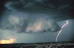
A tornado developing under a wall cloud within a mesocyclone near Falcon, Colorado
Mesocyclone detection algorithm output on tornadic cells in Northern Michigan on July 3, 1999.
References
- ↑ "American Meteorological Society Glossary - Mesocyclone". Archived from the original on 2006-07-09. Retrieved 2006-12-07.
Other websites
| Cyclones and Tropical cyclones of the World |
|---|
| Cyclone - Tropical - Extratropical - Subtropical - Mesocyclone - Polar cyclone - Polar low |


