Travnik
Travnik (Травник) is a town in central Bosnia and Herzegovina, 90 kilometres (56 miles) west of Sarajevo. It is the capital of the Central Bosnia Canton.[1] It is in the Travnik Municipality. In 2013, the town of Travnik had 16,534 residents.[1] The Travnik metropolitan area population was 57,543 people.[1] In 1699 it became the residence of the viziers of the Ottoman province of Bosnia.[2]
|
Травник | |
|---|---|
Town and Municipality | |
 | |
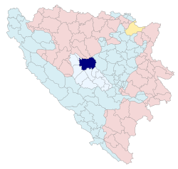
 Location of Travnik within Bosnia and Herzegovina. | |
| Coordinates: 44°13′35″N 17°39′35″E / 44.22639°N 17.65972°ECoordinates: 44°13′35″N 17°39′35″E / 44.22639°N 17.65972°E | |
| Country | Bosnia and Herzegovina |
| Canton | Central Bosnia |
| Government | |
| • Municipality president | Admir Hadžiemrić (SDA) |
| Area | |
| • Town and Municipality | 529 km2 (204 sq mi) |
| Elevation | 514 m (1,686 ft) |
| Population (2013 census) | |
| • Town and Municipality | 16,534 |
| • Density | 109/km2 (280/sq mi) |
| • Urban | 57,543 |
| Time zone | UTC+1 (CET) |
| • Summer (DST) | UTC+2 (CEST) |
| Postal code | 72270 |
| Website | www |
Travnik is close to the geographic center of Bosnia and Herzegovina at 44°14′N 17°40′E / 44.233°N 17.667°E.[3] The river Lašva flows from west to east through the city.[3] Travnik is in the Lašva valley. This valley connects the Bosna river valley to the Vrbas river valley.[4][5]
Travnik is 514 metres (1,686 feet) above sea level.[3] The Vilenica and Vlašić mountains are two of the geographical features found near Travnik.[3] Vlašić mountain is at the very center of Bosnia and Herzegovina.[3] Its highest peak is Paljenik with an elevation of 1,943 metres (6,375 ft).[3]
Travnik Media
Travnik's gymnasium is a classic example of the "Two schools under one roof" system. The right side of the building hosts the Croatian-curriculum high school and was renovated with funds from the Republic of Croatia. The left side of the building hosts the Bosnian-curriculum high school and is dilapidated. The courtyard is separated by a fence.
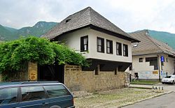
Birthplace of Ivo Andrić
References
- ↑ 1.0 1.1 1.2 "Travnik Video, Tourism and Events". OVGuide. Archived from the original on March 4, 2016. Retrieved December 30, 2016.
- ↑ "Travnik". American Northwest University. Retrieved December 30, 2016.
- ↑ 3.0 3.1 3.2 3.3 3.4 3.5 "Location of Travnik". Traveltill.com. Retrieved December 30, 2016.
- ↑ Mučibabić B., Ed. (1998): Geografski atlas Bosne i Hercegovine. Geodetski zavod BiH, Sarajevo, ISBN 9958-766-00-0., pp: 4-5
- ↑ Vojnogeografski institut, Ed. (1955): Travnik (List karte 1:100.000, Izohipse na 20 m). Vojnogeografski institut, Beograd.
Other websites
![]() Media related to Travnik at Wikimedia Commons
Media related to Travnik at Wikimedia Commons


