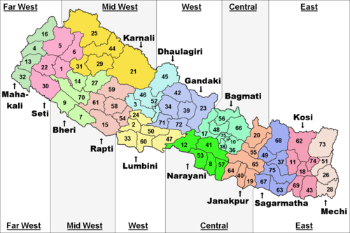
Western Development Region, Nepal
Western Development Region (Nepali: पश्चिमाञ्चल विकास क्षेत्र - Pashchimānchal Bikās Kshetra) was one of Nepal's five development regions. It was in the west-central part of the country. Its headquarters were at Pokhara.
|
Pashchimānchal Bikās Kshetra | |
|---|---|
 | |
| Coordinates: 28°15′50″N 83°58′20″E / 28.26389°N 83.97222°ECoordinates: 28°15′50″N 83°58′20″E / 28.26389°N 83.97222°E | |
| Country | |
| Region | Western Development Region |
| Headquarter | Pokhara, Kaski District, Gandaki Zone |
| Area | |
| • Total | 29,398 km2 (11,351 sq mi) |
| Population (2011 Census) | |
| • Total | 4,926,765 |
| • Density | 167.59/km2 (434.1/sq mi) |
| Time zone | UTC+5:45 (NPT) |
Geography
The Western Development Region had the Central Development Region to the east, the India to the south, the Mid-Western Development Region to the west and the People's Republic of China to the north.
The region was the second largest Development Region of Nepal. Its area was 29,398 square kilometres (11,351 square miles). It was the third in population with 4,926,765 people living there in 2011.[1] Its population density is of 167.6 persons/km2.
Some of the highest mountains of the world were found in this region, in the Himalayas of the Dhawalagiri and Gandaki zones. Among them are Dhaulagiri (8,167 metres [26,795 feet]), Manaslu (8,156 metres [26,759 feet]) and Annapurna (8,091 metres [26,545 feet]).
The most important river in the Western Development Region is the Gandaki, left tributary of the Ganges river.
Cities
Some cities of this region were Pokhara, Baglung, Butwall, Sandhikharka, Tansen, Tilaurakot, etc.
Administrative subdivisions
The region had 3 zones with a total of 16 districts:
| Zone | Population[2] (2011) |
Area[3] (km²) |
Pop. density (inh/km²) |
Districts | |
|---|---|---|---|---|---|
| Number | Names | ||||
| Dhawalagiri | 542,296 | 8,148 | 66.6 | 4 | Baglung, Mustang, Myagdi, Parbat |
| Gandaki | 1,549,857 | 12,275 | 126.3 | 6 | Gorkha, Kaski, Lamjung, Manang, Syangja, Tanahu |
| Lumbini | 2,834,612 | 8,975 | 315.8 | 6 | Arghakhanchi, Gulmi, Kapilvastu, Nawalparasi, Palpa,Rupandehi |
| Total | 9,656,985 | 27,410 | 352.3 | 16 | |
Related pages
References
- ↑ "National Population and Housing Census 2011" (PDF). Central Bureau of Statistics. Kathmandu, Nepal. November 2012. Archived from the original (pdf) on 7 January 2019. Retrieved 12 October 2013.
- ↑ "Nepal: Administrative Division". City Population. Retrieved 12 October 2013.
- ↑ "Regions of Nepal". Statoids. 2012-12-07. Retrieved 12 October 2013.