Anuradhapura
Anuradhapura (Sinhala: අනුරාධපුර, (
|
අනුරාධපුර அனுராதபுரம் | |
|---|---|
 | |
| Coordinates: 8°20′6″N 80°24′39″E / 8.33500°N 80.41083°ECoordinates: 8°20′6″N 80°24′39″E / 8.33500°N 80.41083°E | |
| Country | Sri Lanka |
| Province | North Central Province |
| District | Anuradhapura |
| Established | 5th century BC |
| Government | |
| • Type | Municipal Council |
| Area | |
| • City | 7,179 km2 (2,772 sq mi) |
| • Urban | 36 km2 (14 sq mi) |
| Elevation | 81 m (266 ft) |
| Population (2012) | |
| • City | 50,595 |
| • Density | 2,314/km2 (5,990/sq mi) |
| Time zone | UTC+5:30 (Sri Lanka Standard Time Zone) |
| Postal code | 50000 |
| Official name | Sacred City of Anuradhapura |
| Criteria | Cultural: ii, iii, vi |
| Reference | 200 |
| Inscription | 1982 (6th Session) |
Anuradhapura Media
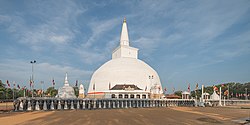
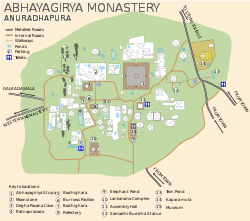
Abhayagiriya Monastery with Samadhi Statue, Kuttam Pokuna (twin pond) and moonstone.
Tamil: அனுராதபுரம்) is a city in Sri Lanka. It is the capital or administrative center of North Central Province in Sri Lanka. As of 2012, Anuradhapura has 50,595 people living in the city.
History
Anuradhapura was founded in the 5th century BCE and was the capital of Sri Lanka from the 4th century BCE until the 11th century CE, when invasions from South India forced Arunadhapura. Arunadhapura was broken and by the Sri Lankan jungle. In the 19th century, Arunadhapura was returned by the British people and became a Buddhist city. The return of Arunadhapura began in 1870. Most of Arunadhapura was moved during the mid-20th century to get the site of the former Sri Lankan capital, is a major road of northern Sri Lanka and lies along a railway line.
Climate
Because Arunadhapura is in the Sri Lankan island, the climate is tropical meaning it is hot in Arunadhapura all year. In October to December, it rains many times in Arunadhapura. The hottest month in Arunadhapura is July.
Economy
Arunadhapura is the headquarters of Sri Lanka’s general view, and tourism is great in Arunadhapura's economy.

