Cartography

Cartography is making maps. It is part of geography. How people make maps is always changing. In the past, maps were drawn by hand, but today most printed maps are made using computers and people usually see maps on computer screens. Someone who makes maps is called a cartographer.
Making a map can be as simple as drawing a direction on a napkin, or as complicated as showing a whole country or world. Anyone can make a map, but cartographers spend their lives learning how to make better maps.
For many centuries maps were usually carefully drawn onto paper or parchment. Now they are made on a computer which makes them look neater with accurate images.[3]
Maps are of two main types:
- General maps with a variety of features.
- Thematic maps with particular themes for specific audiences.[4]
General maps are produced in a series. Governments produce them in larger-scale and smaller-scale maps of great detail.
Thematic maps are now very common. They are necessary to show spatial, cultural and social data.
Cartography Media
A medieval depiction of the Ecumene (1482, Johannes Schnitzer, engraver), constructed after the coordinates in Ptolemy's Geography and using his second map projection. The translation into Latin and dissemination of Geography in Europe, in the beginning of the 15th century, marked the rebirth of scientific cartography, after more than a millennium of stagnation.
The Bedolina Map and its tracing, 6th–4th century BCE
A 14th-century Byzantine map of the British Isles from a manuscript of Ptolemy's Geography, using Greek numerals for its graticule: 52–63°N of the equator and 6–33°E from Ptolemy's Prime Meridian at the Fortunate Isles.
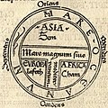
Copy (1472) of St. Isidore's TO map of the world.
The Tabula Rogeriana, drawn by Muhammad al-Idrisi for Roger II of Sicily in 1154. South is at the top.
Europa regina in Sebastian Münster's "Cosmographia", 1570
Double hemisphere map by Hendrik Hondius, 1630
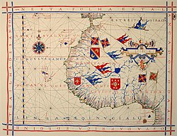
A pre-Mercator nautical chart of 1571, from Portuguese cartographer Fernão Vaz Dourado (c. 1520 – c. 1580). It belongs to the so-called plane chart model, where observed latitudes and magnetic directions are plotted directly into the plane, with a constant scale, as if the Earth were a plane (Portuguese National Archives of Torre do Tombo, Lisbon).
References
| Wikimedia Commons has media related to Lua error in Module:Commons_link at line 62: attempt to index field 'wikibase' (a nil value).. |
- ↑ Robert Kunzig (May 1999). "A Tale of two obsessed archeologists, one ancient city, and nagging doubts about whether science can ever hope to reveal the past". Discover Magazine.
- ↑ Stephanie Meece (2006). "A bird's eye view – of a leopard's spots. The Çatalhöyük 'map' and the development of cartographic representation in prehistory". Anatolian Studies. 56: 1–16. doi:10.1017/S0066154600000727. JSTOR 20065543. S2CID 160549260.
- ↑ Robinson, Arthur H.; Morrison, Joel L.; Muehrcke, Phillip C.; Kimerling, A. Jon; Guptill, Stephen C. (1995). Elements of Cartography. John Wiley & Sons Incorporated. ISBN 978-0-471-55579-7.
- ↑ Robinson, Arthur Howard (1982). Early Thematic Mapping in the History of Cartography. ISBN 978-0-226-72285-6.


