Thematic map

A thematic map is a kind of map. Different from normal maps, a thematic map is designed to show the distribution of human or natural features or data. The information may or may not be related to geography.[1] For example, a map which shows population is a thematic map.
Thematic maps are called so because they show features relating to a particular theme or aspect of geography.
Examples
An early contributor to thematic mapping in England was the English astronomer Edmond Halley (1656–1742).[2] His first important map was a star chart of the constellations of the Southern Hemisphere, published in 1686. In the same year he also published something new, a map of the globe (Earth) in an article about trade winds. This map is sometimes called the first weather map.[2]
Another example of early thematic mapping comes from London physician John Snow. Snow’s cholera map of 1854 is the best known example of using thematic maps for analysis of data. His method anticipates the principles of a geographic information system (GIS). He started with an accurate map of a London neighborhood which included streets and water pump locations. Onto this Snow placed a dot for each cholera death. The pattern centered around one particular pump on Broad Street. At Snow’s request, the handle of the pump was removed, and new cholera cases ceased almost at once. Further investigation of the area revealed the Broad Street pump was near a cesspit under the home of the outbreak's first cholera victim.[3]
Thematic Map Media
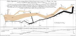
Minard's 1869 flow map of Napoleon's invasion of Russia in 1812–1813. A very innovative thematic map from the 19th century.
Isarithmic map of minimum temperature used as plant hardiness zones.
Edmond Halley's New and Correct Chart Showing the Variations of the Compass (1701), the first chart to show lines of equal magnetic variation.
Choropleth map of water use.
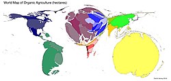
Contiguous cartogram (Gastner-Newman) of the world with each country rescaled in proportion to the hectares of certified organic farming
Isarithmic map of geopotential height.
References
- ↑ Bartz Petchenik, Barbara 1979. "From place to space: the psychological achievement of thematic mapping". Cartography and Geographic Information Science. 6 (1): 5–12.
- ↑ 2.0 2.1 Thrower, Norman J.W. 2008. Maps & civilization: cartography in culture and society. 3rd ed, University of Chicago Press. 97 ISBN 978-0-226-79974-2
- ↑ Robinson, Arthur H. 1982. Early thematic mapping in the history of cartography. University of Chicago Press. ISBN 978-0-226-72285-6


