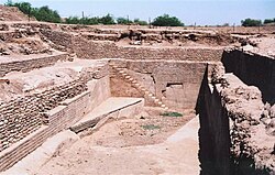
Dholavira
Dholavira (Gujarati: ધોળાવીરા) is an archaeological site. It is at Khadirbet in Bhachau Taluka from the Kutch District. It is in the state of Gujarat in western India. It took its name from a modern-day village 1 kilometre (0.62 mi) south of it. This village is 165 km (103 mi) from Radhanpur.[1][2][3][4][5][6][7]
| Location | Khadirbet, Kutch district, Gujarat, India |
|---|---|
| Coordinates | 23°53′18.98″N 70°12′49.09″E / 23.8886056°N 70.2136361°ECoordinates: 23°53′18.98″N 70°12′49.09″E / 23.8886056°N 70.2136361°E |
| Type | Settlement |
| Area | 47 ha (120 acres) |
| History | |
| Periods | Harappa 1 to Harappa 5 |
| Cultures | Indus Valley Civilization |
| Site notes | |
| Condition | Ruined |
| Public access | Yes |
| Official name | Dholavira: A Harappan City |
| Criteria | Cultural: (iii)(iv) |
| Designated | 2021 (44th session) |
| Reference no. | 1645 |
Signboard
A large signboard with ten big symbols of the Indus script was found near the north gate of Dholavira. The signs were made from white gypsum and set into a wooden frame. Many scholars think the signboard shows how important symbols were in the city.
A 2025 study by Max Freedom Pollard suggests that the signboard shows the parts of an animal-drawn cart in order.[8]
Dholavira Media
Dholavira is an archaeological site in Kutch district, India. It is one of the five largest Harappan sites and most prominent archaeological sites in India belonging to the Indus Valley Civilizations. The site was occupied from c.2650 BCE, declining slowly after about 2100 BCE. It was briefly abandoned then reoccupied until c.1450 BCE.
Dholavira is an archaeological site in Kutch district, India. It is one of the five largest Harappan sites and most prominent archaeological sites in India belonging to the Indus Valley Civilizations. The site was occupied from c.2650 BCE, declining slowly after about 2100 BCE. It was briefly abandoned then reoccupied until c.1450 BCE.
Ten Indus characters from the northern gate of Dholavira, dubbed the Dholavira Signboard.
References
- ↑ Gopinath, P. Krishna (15 July 2017). Ruins on the Tropic of Cancer. http://www.thehindu.com/society/ruins-on-the-tropic-of-cancer/article19284214.ece.
- ↑ Subramanian, T. "The rise and fall of a Harappan city". The Archaeology News Network. Archived from the original on 30 June 2016. Retrieved 3 June 2016.
- ↑ "Where does history begin?". 19 October 2017.
- ↑ Kenoyer & Heuston, Jonathan Mark & Kimberley (2005). The Ancient South Asian World. New York: Oxford University Press. p. 55. ISBN 9780195222432.
- ↑ Centre, UNESCO World Heritage. "Dholavira: A Harappan City - UNESCO World Heritage Centre". whc.unesco.org. Retrieved 3 June 2016.
- ↑ Possehl, Gregory L. (2002). The Indus Civilization: A Contemporary Perspective. Rowman Altamira. p. 17. ISBN 9780759101722. Retrieved 3 June 2016.
- ↑ Sengupta, Torsa; Deshpande Mukherjee, Arati; Bhushan, Ravi; Ram, F.; Bera, M. K.; Raj, Harsh; Dabhi, Ankur J.; Bisht, R. S.; Rawat, Y. S.; Bhattacharya, S. K.; Juyal, Navin; Sarkar, Anindya (2020). "Did the Harappan settlement of Dholavira (India) collapse during the onset of Meghalayan stage drought?". Journal of Quaternary Science. 35 (3): 382–395. doi:10.1002/jqs.3178. S2CID 214252156.
- ↑ Max Freedom Pollard (14 November 2025). "Indus Signs as Merchant Marks: Corpus Structure, Context, and Viability". Cambridge Open Engage (Working paper). Cambridge University Press. doi:10.33774/coe-2025-n0cxj. Retrieved 19 November 2025.
Other websites
| Wikimedia Commons has media related to Lua error in Module:Commons_link at line 62: attempt to index field 'wikibase' (a nil value).. |
- Excavations at Dholavira in Archaeological Survey of India website
- Dholavira Pictures by Archaeological Survey of India website
- Jurassic Park: Forest officials stumble upon priceless discovery near Dholavira; Express news service; 8 Jan 2007; Indian Express Newspaper
- ASI’s effort to put Dholavira on World Heritage map hits the roadblock; by Hitarth Pandya; 13 Feb 2009; Indian Express Newspaper
- ASI to take up excavation in Kutch's Khirasara; by Prashant Rupera, TNN; 2 November 2009; Times of India


