Division of Bradfield
The Division of Bradfield is an Australian Electoral Division in New South Wales. It was created in 1949 and is named for Dr John Bradfield,[1] the designer of the Sydney Harbour Bridge.
| Bradfield Australian House of Representatives Division | |
|---|---|
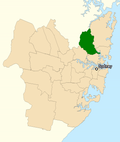
 Division of Bradfield (green) in New South Wales | |
| Created | 1949 |
| Namesake | John Bradfield |
| Electors | 97,255 (2010) |
| Area | 99 km2 (38.2 sq mi) |
| Demographic | Inner Metropolitan |
It includes the suburbs of St Ives Chase, St Ives, East Killara, East Lindfield, Roseville Chase, Roseville, Lindfield, West Lindfield, West Killara, West Pymble, South Turramurra, Thornleigh, Gordon, Lindfield, Pymble, Killara, Wahroonga, Waitara and Hornsby.[1]
Bradfield is the richest electorate in Australia.[2]
Members
| Member | Party | Term | |
|---|---|---|---|
| Billy Hughes | Liberal | 1949–1952 | |
| Harry Turner | Liberal | 1952–1974 | |
| David Connolly | Liberal | 1974–1996 | |
| Brendan Nelson | Liberal | 1996–2009 | |
| Paul Fletcher | Liberal | 2009–2025 | |
| Nicolette Boele | Independent | 2025–present | |
Billy Hughes was a former Prime Minister of Australia and the last serving member of the first federal Parliament. Brendan Nelson was a minister in the third and fourth Howard Governments and the Leader of the Opposition from 2007 to 2008.
Election results
| 2022 Australian federal election: Bradfield[3] | |||||
|---|---|---|---|---|---|
| Party | Candidate | Votes | % | ±% | |
| Liberal | Paul Fletcher | 43,562 | 45.05 | −15.28 | |
| Independent | Nicolette Boele | 20,198 | 20.89 | +20.89 | |
| Labor | David Brigden | 16,902 | 17.48 | −3.70 | |
| Greens | Martin Cousins | 8,960 | 9.27 | −4.44 | |
| Independent | Janine Kitson | 3,018 | 3.12 | +3.12 | |
| United Australia | Rob Fletcher | 2,496 | 2.58 | +0.74 | |
| One Nation | Michael Lowe | 1,568 | 1.62 | +1.62 | |
| Total formal votes | 96,704 | 96.40 | +0.45 | ||
| Informal votes | 3,616 | 3.60 | −0.45 | ||
| Turnout | 100,320 | 92.43 | −0.95 | ||
| Notional two-party-preferred count | |||||
| Liberal | Paul Fletcher | 54,685 | 56.55 | −10.01 | |
| Labor | David Brigden | 42,019 | 43.45 | +10.01 | |
| Two-candidate-preferred result | |||||
| Liberal | Paul Fletcher | 52,447 | 54.23 | −12.33 | |
| Independent | Nicolette Boele | 44,257 | 45.77 | +45.77 | |
| Template:Australian politics/name/Liberal hold | Swing | –12.33 | |||
Division Of Bradfield Media
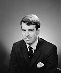
John Bradfield, the division's namesake
References
- ↑ 1.0 1.1 "Profile of the electoral division of Bradfield (NSW)". Australian Electoral Commission. 22 February 2012. Retrieved 6 April 2012.
- ↑ "Mumble election tables – Median weekly household income". mumble.com.au. 2013. Archived from the original on 19 August 2013. Retrieved 19 August 2013.
- ↑ Bradfield, NSW, 2022 Tally Room, Australian Electoral Commission.


