Division of Gorton
The Division of Gorton is an Australian Electoral Division in Victoria. It was set up in 2004 and is named for Sir John Gorton, Prime Minister of Australia from 1968 to 1971.[1] It covers the outer western suburbs of Melbourne. It includes the suburbs of Hillside, Delahey, Kings Park, Caroline Springs, Deer Park, Cairnlea and Melton as well as the satellite townships of Diggers Rest and Toolern Vale.[1]
| Gorton Australian House of Representatives Division | |
|---|---|
 Division of Gorton (green) in Victoria | |
| Created | 2004 |
| Namesake | John Gorton |
| Electors | 113,675 (2010) |
| Area | 166 km2 (64.1 sq mi) |
| Demographic | Outer Metropolitan |
Members
| Member | Party | Term | |
|---|---|---|---|
| Brendan O'Connor | Labor | 2004–2022 | |
Brendan O'Connor had also been the member for the Division of Burke. He has held several Ministerial positions in the Rudd Government and the Gillard Government These have included Immigration and Citizenship, Housing, Human Services, Skills and Training, Small Business, and Employment.
Election results
| 2022 Australian federal election: Gorton[2] | |||||
|---|---|---|---|---|---|
| Party | Candidate | Votes | % | ±% | |
| Labor | Brendan O'Connor | 38,178 | 41.30 | −10.13 | |
| Liberal | John Fletcher | 25,350 | 27.42 | −0.56 | |
| Greens | Praise Morris | 8,325 | 9.01 | +1.58 | |
| United Australia | Michael Virag | 7,082 | 7.66 | +0.36 | |
| One Nation | Daniel Connor | 6,719 | 7.27 | +7.27 | |
| Independent | Steven Loncar | 2,341 | 2.53 | +2.53 | |
| Victorian Socialists | Belle Gibson | 2,064 | 2.23 | +2.23 | |
| Great Australian | Tony Dobran | 1,312 | 1.42 | +0.64 | |
| Australian Federation | Paul Lassig | 1,063 | 1.15 | +1.15 | |
| Total formal votes | 92,434 | 92.88 | −1.04 | ||
| Informal votes | 7,089 | 7.12 | +1.04 | ||
| Turnout | 99,523 | 89.77 | −1.24 | ||
| Two-party-preferred result | |||||
| Labor | Brendan O'Connor | 55,434 | 59.97 | −4.27 | |
| Liberal | John Fletcher | 37,000 | 40.03 | +4.27 | |
| Labor hold | Swing | −4.27 | |||
Division Of Gorton Media
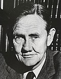
Sir John Gorton, the division's namesake
References
- ↑ 1.0 1.1 "Profile of the electoral division of Gorton (Vic)". Australian Electoral Commission. 2013. Retrieved 13 August 2013.
- ↑ Gorton, VIC, 2022 Tally Room, Australian Electoral Commission.


