Hook echo

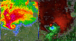
A hook echo on the radar image of the May 3, 1999 supercell thunderstorm that produced an F5 tornado in Moore, Oklahoma.
A hook echo is a hook shape seen on a weather radar of some supercell thunderstorms. It is produced by rain, hail, or even debris wrapping around the thunderstorm.[1] A hook echo is a sign that a tornado has formed or is forming. If a hook echo is seen on radar, the National Weather Service may issue a tornado warning.[2]
Hook Echo Media
Classic hook echo can be seen for this Kansas EF2 tornado in 2024
References
- ↑ Glickman, Todd S., ed. (2000). Glossary of Meteorology (2nd ed.). American Meteorological Society. ISBN 978-1-878220-34-9.
- ↑ Angel, Jim (Apr 9, 2013). "ISWS is Pioneer in Tracking Tornadoes by Radar". Illinois State Water Survey. Archived from the original on 2013-06-01. Retrieved 2013-05-22.

