La Paz
Nuestra Señora de La Paz (Spanish pronunciation: [ˈnwes.tɾa seˈɲoɾa ðe la pas]; English: [Our Lady of Peace] Error: {{Lang}}: text has italic markup (help); Aymara: [Chuqi Yapu] Error: {{Lang}}: text has italic markup (help))[5] is the capital of Bolivia, and La Paz Department. It is the second largest city (in people) only after Santa Cruz de la Sierra.[3] It is in the western part of the country in the department of the same name. It is at an elevation of 3,650 m (11,975 ft) above sea level, making it the world's highest de facto capital city.
 | |
|
| |
| Coordinates: 16°30′S 68°09′W / 16.500°S 68.150°WCoordinates: 16°30′S 68°09′W / 16.500°S 68.150°W | |
| Country | Bolivia |
| Department | La Paz |
| Province | Pedro Domingo Murillo |
| Founded | October 20, 1548 |
| Independence | July 16, 1809 |
| Incorporated (El Alto) | 20th century |
| Founded by | Alonso de Mendoza |
| Government | |
| • Mayor | Luis Antonio Revilla Herrero [2] |
| Area | |
| • City | 472 km2 (182 sq mi) |
| • Urban | 3,240 km2 (1,250 sq mi) |
| Elevation | 3,640 m (11,942 ft) |
| Population (2008[3]) | |
| • City | 877,363 |
| • Density | 6,275.16/km2 (16,252.6/sq mi) |
| • Metro | 2,364,235 |
| Time zone | GMT-4 |
| HDI (2010) | 0.672 – high[4] |
| Website | www.lapaz.bo |
La Paz Media
Calle Jaén in the historic center of La Paz, contains well-preserved Spanish Colonial buildings.
Plaza Murrillo, the city's main square, seen in 1987.
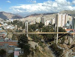
La Paz is characterized by its mountainous geography, the snow-capped Illimani dominates the city's skyline
References
- ↑ Breve Historia de nuestro país (pág.3) Archived 2012-03-16 at the Wayback Machine, Bolivian Government Official Website(in Spanish)
- ↑ "¿Quién es Luis Revilla?". Luchoporlapaz.com. Archived from the original on 2010-07-16. Retrieved 2010-07-04.
- ↑ 3.0 3.1 "World Gazetteer". World Gazetteer. Retrieved 2010-01-31.[dead link]
- ↑ "W.K. Kellogg Foundation: Overview – Bolivia: La Paz – El Alto". Archived from the original on 2020-02-13. Retrieved 2011-08-11.
- ↑ Yaticha Kamani / Ministerio de Educación, Aymara aru thakhinchawi, Chuqi Yapu 2011


