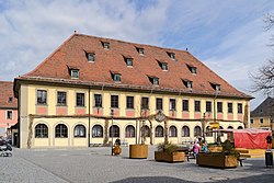
Lichtenfels, Bavaria
Lichtenfels is a town in the Upper Franconian region of Bavaria, Germany, the administrative seat of Lichtenfels district. It is mainly known as the German "Basket City".
 | |
Location of Lichtenfels within Lichtenfels district | |
| Coordinates: 50°08′N 11°02′E / 50.133°N 11.033°ECoordinates: 50°08′N 11°02′E / 50.133°N 11.033°E | |
| Country | Germany |
| State | Bavaria |
| Admin. region | Oberfranken |
| District | Lichtenfels |
| Government | |
| • Mayor (2020–26) | Andreas Hügerich[1] (SPD) |
| Area | |
| • Total | 122.27 km2 (47.21 sq mi) |
| Elevation | 271 m (889 ft) |
| Population (2016-12-31)[2] | |
| • Total | 20,064 |
| • Density | 164.096/km2 (425.006/sq mi) |
| Time zone | UTC+01:00 (CET) |
| • Summer (DST) | UTC+02:00 (CEST) |
| Postal codes | 96215 |
| Vehicle registration | LIF, STE |
| Website | www |
Geography
It is on the upper path of the river Main, about 15 kilometres (9.3 mi) southeast of Coburg, and 30 kilometres (19 mi) northeast of Bamberg. The hilly landscape is called Gottesgarten am Obermain ("God's garden on the upper Main"), referring to the Basilica of the Fourteen Holy Helpers and Banz Abbey. The Maintal (valley of the Main) goes from East to West. The most important cities of the district are Burgkunstadt, Bad Staffelstein and the district city of Lichtenfels. The Rodach river, a tributary of the Main, runs through the area and reaches its greatest width in the northern part between Hochstadt am Main and Lichtenfels.
The district of Lichtenfels is in the western part of the government region (Regierungsbezirk) of Oberfranken (Upper Franconia). It is surrounded by (from the north and clockwise) the districts of Coburg, Kronach, Kulmbach, Bayreuth and Bamberg.
The southern edge of the Main stretches up to the mountain range of the Franconian Jura (Fränkische Alb) below the Staffelberg close to Bad Staffelstein. The northern edge of the Main stretches up to the Itz-Baunach Highlands.
Administrative division
The town is divided into several districts:
Buch am Forst, Degendorf, Eichig, Gnellenroth, Hammer, Isling, Klosterlangheim, Kösten, Köttel, Krappenroth, Lahm, Mistelfeld, Mönchkröttendorf, Oberlangheim, Oberwallenstadt, Reundorf, Roth, Rothmannsthal, Schney, Schönsreuth, Seehof, Seubelsdorf, Stetten, Stöcken, Tiefenroth, Trieb, Unterwallenstadt und Weingarten.
Twin towns – sister cities
Lichtenfels is twinned with:[3]
- File:Flag of Italy.svg Ariccia, Italy (2004)
- File:Flag of France.svg Cournon-d'Auvergne, France (1992)
- 23x15px Prestwick, Scotland, United Kingdom (1974)
 Vandalia, United States (1975)
Lichtenfels, Bavaria Media
References
- ↑ Liste der ersten Bürgermeister/Oberbürgermeister in kreisangehörigen Gemeinden, Bayerisches Landesamt für Statistik, 15 July 2021.
- ↑ "Fortschreibung des Bevölkerungsstandes". Bayerisches Landesamt für Statistik und Datenverarbeitung (in German). January 2018.
{{cite web}}: CS1 maint: unrecognized language (link) - ↑ "Unsere Partnerstädte". lichtenfels.de (in Deutsch). Lichtenfels. Archived from the original on 2021-01-17. Retrieved 2021-02-18.
| Wikimedia Commons has media related to Lua error in Module:Commons_link at line 62: attempt to index field 'wikibase' (a nil value).. |


