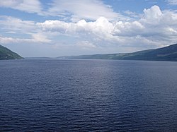
Loch Ness
Loch Ness is a loch in the Scottish Highlands. It is also on the Great Glen Fault and part of the Caledonian Canal.
| Loch Ness | |
|---|---|
 With Urquhart Castle in the foreground | |
| Location | Scottish Highlands |
| Type | freshwater loch, dimictic, oligotrophic[1] |
| Primary inflows | River Oich/Caledonian Canal, River Moriston, River Foyers, River Enrick, River Coiltie |
| Primary outflows | River Ness |
| Catchment area | 1,770 km2 (685 sq mi) |
| Basin countries | Scotland |
| Max. length | 36.2 km (22.5 mi) |
| Max. width | 2.7 km (1.7 mi) |
| Surface area | 56 km2 (21.8 sq mi) |
| Average depth | 132 m (433 ft) |
| Max. depth | 226.96 m (124.10 fathoms; 744.6 ft) |
| Water volume | 7.5 km3 (1.8 cu mi) |
| Surface elevation | 15.8 m (52 ft) |
| Islands | 1 (Cherry Island) |
Geography
Loch Ness is 36 kilometres long and only 1.5 kilometres wide. It is the second largest Scottish loch by surface area at 56.4 km2 (21.8 sq mi), after Loch Lomond. Because of its great depth, it is the largest by volume. Its deepest point is 230 m (755 ft).[2][3] This is deeper than any other loch except Loch Morar.
It has more freshwater than all the lakes in England and Wales combined,[3] and is the largest body of water on the Great Glen Fault, which runs from Inverness in the north to Fort William in the south. In popular legend, it is the home of the "Loch Ness Monster", a mythological creature in Scottish folklore.
Loch Ness Media
Urquhart Bay and Loch Ness viewed from Grant's Tower at Urquhart Castle
Locks on Caledonian Canal in Fort Augustus, Loch Ness in the background
Sunrise over Loch Ness, taken at Urquhart Castle
References
- ↑ Dill, W.A. (1993). Inland Fisheries of Europe, p. 227. EIFAC FAO Technical Report 52 suppl.
- ↑ "Bathymetrical Survey of the Fresh-Water Lochs of Scotland, 1897–1909". National Library of Scotland. Archived from the original on 2007-02-08.
- ↑ 3.0 3.1 "Ness, Loch". The Gazetteer for Scotland. Retrieved 2010-02-09.


