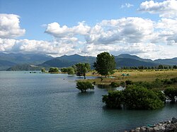
Maule Region
The VII Maule Region (Spanish: VII Región del Maule) is one of Chile's 16 first order administrative divisions. Its capital is Talca.
|
Región del Maule | |
|---|---|
 | |
Flag of Flag | |
| Map of Maule Region Map of Maule Region | |
| Coordinates: 35°26′S 71°40′W / 35.433°S 71.667°WCoordinates: 35°26′S 71°40′W / 35.433°S 71.667°W | |
| Country | |
| Capital | Talca |
| Provinces | Curicó, Talca, Linares, Cauquenes |
| Government | |
| • Intendant | Pablo Milad (Evopoli) |
| Area | |
| • Total | 30,296.1 km2 (11,697.4 sq mi) |
| • Rank | 9 |
| Lowest elevation | 0 m (0 ft) |
| Population (2017 census)[1] | |
| • Total | 1,033,197 |
| • Rank | 4 |
| • Density | 34.10330/km2 (88.32714/sq mi) |
| ISO 3166 code | CL-ML |
| HDI (2019) | 0.790[2] high |
| Website | Official website (in Spanish) |
The region is named after its main river: the Maule river.
History
The city of Talca was founded in 1692 by General Governor Tomás Marín de Poveda. On 17 February 1742 it got the name of Villa San Agustín de Talca by Governor José Antonio Manso de Velasco. Curicó followed in 1743, Linares and Parral in 1794.
In Talca is the house where Bernardo O'Higgins signed the proclamation of the independence of Chile on 12 February 1818. It is now a museum.
Geography
The Maule region borders the Libertador General Bernardo O'Higgins region to the north, Argentina to the east, the Ñuble region to the south and the Pacific Ocean on the west.[3]
The two main rivers in the region are the Maule and the Mataquito rivers.
Population
As of 2015[update], there were (estimated) 1,042,989 persons living in the region,[4] for a population density of 34.4 inhabitants/km².
People from this region are known as Maulinos (women: Maulinas).
The largest city in the region is Talca, with 189,505 inhabitants (2002 census).
Administration
The Maule region is further subdivided into four provinces: Talca, Curicó, Linares and Cauquenes.
| Province | Capital | Code | Comuna | Area[3] (km²) |
Population[3] (2002) |
|---|---|---|---|---|---|
| Talca (071) | Talca | 07101 | 30 Talca | 231.5 | 201,797 |
| 07102 | 21 Constitución | 1,343.6 | 46,081 | ||
| 07103 | 22 Curepto | 1,073.8 | 10,812 | ||
| 07104 | 23 Empedrado | 564.9 | 4,225 | ||
| 07105 | 24 Maule | 238.2 | 16,837 | ||
| 07106 | 25 Pelarco | 331.5 | 7,266 | ||
| 07107 | 26 Pencahue | 956.8 | 8,315 | ||
| 07108 | 27 Río Claro | 430.5 | 12,698 | ||
| 07109 | 28 San Clemente | 4,503.6 | 37,261 | ||
| 07110 | 29 San Rafael | 263.5 | 7,674 | ||
| Total of Talca province | 9,937.8 | 352,966 | |||
| Cauquenes (072) | Cauquenes | ||||
| 07201 | 1 Cauquenes | 2,126.3 | 41,217 | ||
| 07202 | 2 Chanco | 529.5 | 9,457 | ||
| 07203 | 3 Pelluhue | 371.4 | 6,414 | ||
| Total of Cauquenes province | 3,027.2 | 57,088 | |||
| Curicó (073) | Curicó | ||||
| 07301 | 4 Curicó | 1,328.4 | 119,585 | ||
| 07302 | 5 Hualañé | 629.0 | 9,741 | ||
| 07303 | 6 Licantén | 273.3 | 6,902 | ||
| 07304 | 7 Molina | 1,551.6 | 38,521 | ||
| 07305 | 8 Rauco | 308.6 | 8,566 | ||
| 07306 | 9 Romeral | 1,597.1 | 12,707 | ||
| 07307 | 10 Sagrada Familia | 548.8 | 17,519 | ||
| 07308 | 11 Teno | 618.4 | 25,596 | ||
| 07309 | 12 Vichuquén | 425.7 | 4,916 | ||
| Total of Curicó province | 7,280.9 | 244,053 | |||
| Linares (074) | Linares | ||||
| 07401 | 14 Linares | 1,465.7 | 83,249 | ||
| 07402 | 13 Colbún | 2,899.9 | 17,619 | ||
| 07403 | 15 Longaví | 1,453.8 | 28,161 | ||
| 07404 | 16 Parral | 1,638.4 | 37,822 | ||
| 07405 | 17 Retiro | 827.1 | 18,487 | ||
| 07406 | 18 San Javier | 1,313.4 | 37,793 | ||
| 07407 | 19 Villa Alegre | 189.8 | 14,725 | ||
| 07408 | 20 Yerbas Buenas | 262.1 | 16,134 | ||
| Total of Linares province | 10,050.2 | 253,990 | |||
| Total of the region | 30,296.1 | 908,097 | |||
Related pages
References
- ↑ 1.0 1.1 "Maule Region". Government of Chile Foreign Investment Committee. Retrieved 13 March 2010.[dead link]
- ↑ "Sub-national HDI - Area Database - Global Data Lab". hdi.globaldatalab.org. Retrieved 26 October 2021.
- ↑ 3.0 3.1 3.2 "Región de Maule" (PDF). Instituto Nacional de Estadísticas. Archived from the original (PDF) on 26 June 2016. Retrieved 14 October 2016.
- ↑ "Población país y regiones - Actualización 2002-2012 y Proyección 2013-2020" (XLS) (in español). Instituto Nacional de Estadísticas (INE). 4 September 2014. Retrieved 14 October 2016.
Other websites
| Wikimedia Commons has media related to Lua error in Module:Commons_link at line 62: attempt to index field 'wikibase' (a nil value).. |
- Territorial division of Chile (in Spanish)
- Gobierno Regional del Maule Archived 2016-11-06 at the Wayback Machine Official website (in Spanish)
| Regions of Chile | |
|---|---|
| Arica y Parinacota | Tarapacá | Antofagasta | Atacama | Coquimbo | Valparaíso | O'Higgins | Maule | Ñuble | Bío Bío | La Araucanía | Los Ríos | Los Lagos | Aysén | Magallanes y la Antártica Chilena | RM Santiago | |
