Murshidabad-Jiaganj
Murshidabad-Jiaganj[1] is a community development block that forms an administrative division in the Lalbag subdivision of Murshidabad district in the Indian state of West Bengal.[2][3]
Community development block | |
 | |
| Coordinates: 24°14′N 88°16′E / 24.23°N 88.27°ECoordinates: 24°14′N 88°16′E / 24.23°N 88.27°E | |
| Country | |
| State | West Bengal |
| District | Murshidabad |
| Government | |
| • Type | Federal democracy |
| Area | |
| • Total | 208.62 km2 (80.55 sq mi) |
| Elevation | 20 m (70 ft) |
| Population (2011) | |
| • Total | 234,565 |
| • Density | 1,124.365/km2 (2,912.09/sq mi) |
| Languages | |
| • Official | Bengali, English |
| Literacy | |
| • Literacy (2011) | 69.14% |
| Time zone | UTC+5:30 (IST) |
| PIN | 742149 (Murshidabad) 742187 (Radharghat) 742140 (Jemo Rajbati) 742113 (Jiaganj) |
| ISO 3166 code | IN-WB |
| Vehicle registration | WB-57, WB-58 |
| Lok Sabha constituency | Murshidabad |
| Vidhan Sabha constituency | Murshidabad |
| Website | murshidabad |
Murshidabad-Jiaganj Media

Terracotta relief at one of the Char Bangla Temples. It is shows the Last prayer of Ravana, the most famous among the wall-reliefs of Baronagar.

Khushbagh:The cemetery at Khusbagh hosts the graves of the Nawabs of Bengal of the Afshar dynasty and their family members. It is the resting place, amongst others, of Nawab Alivardi Khan, Nawab Siraj ud-Daula, his wife Lutfunnisa Begum, his mother Amina Begum and his maternal aunt Ghaseti Begum.

Rosnaibagh: It is the resting place of Nawab Shuja-ud-Din Muhammad Khan. It is an ASI Listed Monument.

Baranagar: It has several temples built by Rani Bhabani. Of these, Char Bangla Temples (partially shown in the picture) and Bhavaniswar Mandir are ASI Listed Monuments.
Nashipur: The current Rajbari was built by Raja Kirti Chandra Singha Bahadur in 1865, next to the old palace of Raja Debi Singha.

House of Jagat Seth : It was built in 1704. In 1715, Manik Chand, was conferred the title of Nagar Seth, the banker of the city, and Fateh Chand, was given the hereditary title of Jagat Seth, in 1723, by the Mughal emperors of their time. It is now a museum.

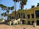
Kathgola Palace : The palace and garden at Kathgola were built by Dhanpat Singh Dugar and Lakshmipat Singh Dugar in 1873. It is now a museum.

Katra Masjid: Built by Nawab Murshid Quli Khan in 1723-24, the Nawab’s tomb is located adjacent to the mosque. It is an ASI Listed Monument.

Fauti Masjid: Built by Nawab Sarfaraz Khan in 1740, it remains an unfinished construction.

Jama Masjid, Motijheel: Located on the western bank of Motijhil, it was built by Nawab Nawaei Muhammad Khan in 1750. It is an ASI Listed Monument
.jpg)


-Murshidabad-West_Bengal-0002.jpg)

Other Website
![]() Murshidabad travel guide from Wikivoyage
Murshidabad travel guide from Wikivoyage
References
- ↑ "District Census Handbook: Murshidabad, Series 20 Part XII A" (PDF). Physiography, Page 13. Directorate of Census Operations, West Bengal, 2011. Retrieved 24 July 2017.
- ↑ "Types and sources of floods in Murshidabad, West Bengal" (PDF). Swati Mollah. Indian Journal of Applied Research, February 2013. Archived from the original (PDF) on 20 August 2017. Retrieved 15 August 2017.
- ↑ "Murshidabad". Geography. Murshidabad district authorities. Retrieved 24 July 2017.