North Rhine-Westphalia
North Rhine-Westpalia (German: [ Nordrhein-Westfalen] Error: {{Lang}}: text has italic markup (help), Low Fanconian: Noordrie-Wesfale, Low German: Niggrdrhien-Westfalen, Kölsch: Noodrhing-Wäßßfaale) is the federal state (Bundesland) with the highest population in Germany. It is in the western part of Germany and has 18,033,000 inhabitants. The capital is Düsseldorf, while the city with the most inhabitants is Cologne.
|
Nordrhein-Westfalen | |
|---|---|
 Flag  Coat of arms | |
 | |
| Country | Germany |
| Capital | Düsseldorf |
| Government | |
| • Minister President | Hendrik Wüst (CDU) |
| • Governing parties | CDU / FDP |
| Area | |
| • Total | 34,084 km2 (13,160 sq mi) |
| Population | |
| • Total | 18,033,000 |
| • Density | 529.075/km2 (1,370.30/sq mi) |
| Time zone | UTC+1 (CET) |
| • Summer (DST) | UTC+2 (CEST) |
| Website | nrw.de |
Districts
North Rhine-Westphalia is divided into five government regions:
History
- 1807-1813 — Westphalia is a kingdom.
- 1817 — Westphalia became a province of Prussia.
- 1824 — Jülich, Kleve, Berg and Niederrhein united to Rhine Province.
- 1919 — Belgium took Eupen and Malmedy.
- 1946 — Rhine Province, Westphalia and Lippe-Detmold united to North Rhine-Westphalia.
Cities
- Aachen
- Bergisch Gladbach
- Bielefeld
- Bocholt
- Bochum
- Bonn
- Bottrop
- Castrop-Rauxel
- Cologne
- Dinslaken
- Dortmund
- Düren
- Düsseldorf
- Duisburg
- Essen
- Geldern
- Gelsenkirchen
- Gütersloh
- Hagen
- Hamm
- Hattingen
- Heinsberg
- Herne
- Iserlohn
- Köln
- Krefeld
- Leverkusen
- Lippstadt
- Lünen
- Marl
- Moers
- Mönchengladbach
- Mülheim an der Ruhr
- Münster
- Neuss
- Oberhausen
- Paderborn
- Ratingen
- Recklinghausen
- Remscheid
- Siegen
- Solingen
- Unna
- Velbert
- Wesel
- Wuppertal
- Witten
- Xanten
North Rhine-Westphalia Media
Additional map exhibiting the region
Map of the Lower Rhenish–Westphalian Circle in 1799 by John Cary
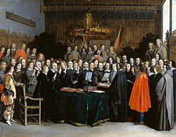
Ratification of the Peace of Westphalia of 1648 in Münster by Gerard Terborch
Geographic map of North Rhine-Westphalia

The highest peaks in North Rhine-Westphalia are located in the Rothaar Mountains.
State border with North Rhine-Westphalia near Warburg; in the background the Desenberg, with 345 m landmark and highest point in the Warburger Börde near the border triangle NRW - Hesse - Lower Saxony
North rhine w Landschaftsverbände
Regierungsbezirk Düsseldorf
Map of w:de:Regierungsbezirk Arnsberg, a District of Northrhine-Westphalia (NRW), Germany. Red/Grey colors match the color scheme of Germany maps and information boxes in German Wikipedia. District is highlighted in red. Former version of map was based upon

Map of Regierungsbezirk Köln, a Bezirk of Northrhine-Westphalia (NRW), Germany. Red/Grey colors match the color scheme of Germany maps and information boxes in German Wikipedia. Bezirk is highlighted in red. Former v
.jpg)

