Okinawa Prefecture
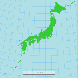
Okinawa Prefecture (沖縄県, Japanese: Okinawa-ken, Okinawan: Uchinaa-chin[1]) is traditionally a prefecture in the Kyūshū region of Japan.[2] Okinawa Prefecture is made up of islands which are southwest of the island of Kyushu.[3] Recent government proposals recognize the prefecture as its own region.[4]
|
沖縄県 | |
|---|---|
| Native transcription(s) | |
| • Japanese | Okinawa-ken |
| • Okinawan | ʔUchinā-chin |
 | |
| Coordinates: 26°30′N 128°0′E / 26.500°N 128.000°ECoordinates: 26°30′N 128°0′E / 26.500°N 128.000°E | |
| Country | |
| Region | Kyushu |
| Island | Okinawa, Daitō, Sakishima and Senkaku (disputed) |
| Capital | Naha |
| Subdivisions | Districts: 5, Municipalities: 41 |
| Government | |
| • Governor | Denny Tamaki |
| Area | |
| • Total | 2,281 km2 (881 sq mi) |
| • Rank | 44th |
| Population (February 2, 2020) | |
| • Total | 1,457,162 |
| • Rank | 29th |
| • Density | 638.83/km2 (1,654.6/sq mi) |
| ISO 3166 code | JP-47 |
| Website | www |
| Symbols | |
| Bird | Okinawa woodpecker (Sapheopipo noguchii) |
| Fish | Banana fish (Pterocaesio diagramma, "takasago", "gurukun") |
| Flower | Deego (Erythrina variegata) |
| Tree | Pinus luchuensis ("ryūkyūmatsu") |
The capital city is Naha which is on the island of Okinawa.[5]
History
Timeline
- 1429: Shō Hashi founded the Ryūkyū Kingdom
- 1609: Shimazu of Satsuma Province invade Ryukyu Kingdom
- 1853: Commodore Mathew Perry and US Navy ships at Naha
- 1875 (Meiji 5): Ryūkyū Domain is created
- 1879 (Meiji 12): Okinawa Prefecture was established.
- 1945 (Shōwa 20): US administration after World War II[6]
- 1953 (Shōwa 28): Partial reversion to Japan[6]
- 1972 (Shōwa 47): Reversion to Japan[6]
- 2000 (Heisei 12): 26th G8 summit at Kyushu and Okinawa[7]
Geography
Okinawa is a grouping of many islands along the border at the edge of the East China Sea and the Pacific Ocean from Kyūshū to Taiwan. It is the southernmost prefecture in Japan.[3]
Cities
Okinawa Prefecture has eleven cities. Okinawan names are in parentheses.
Towns and villages
These are the towns and villages in each district.
National Parks
National Parks are established in about 19% of the total land area of the prefecture.[8]
Shrines and Temples
Naminouegū was the chief Shinto shrine (ichinomiya) of the Ryukyu Islands.[9] In 1890, the shrine was recognized in the system of State Shinto. It is among the ranked, nationally significant shrines or Kanpei-shōsha (官幣小社) which includes five sanctuaries.[10]
Okinawa Prefecture Media
A depiction of the 1710 Ryukyuan mission to Edo
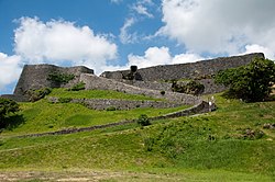
Ruins of Katsuren Castle
Enkaku-ji, the royal mausoleum temple of the Second Shō Dynasty
Related pages
References
- ↑ JLect - ちん【県・縣】 : chin | define meaning. www.jlect.com. Archived from the original on June 17, 2016. Retrieved 2020-09-28.
- ↑ Kanno, Eiji. (1998). New Japan Solo, p. 397; excerpt, "Administratively, Okinawa is part of Kyushu Region, even though it is l .000 km (625 miles) southwest of Kagoshima."
- ↑ 3.0 3.1 Nussbaum, Louis-Frédéric. (2005). "Okinawa-ken" in Japan Encyclopedia, pp. 746-747.
- ↑ Hook, Glenn D. (2011). Decoding Boundaries in Contemporary Japan: The Koizumi Administration and Beyond, pp. 145-146.
- ↑ Nussbaum, "Naha" at p. 686.
- ↑ 6.0 6.1 6.2 Nussbaum, "Ryukyu Islands" at p. 801.
- ↑ Japan, Ministry of Foreign Affairs (MOFA): 26th G8 summit, overview.
- ↑ Japan Ministry of the Environment, "General overview of area figures for Natural Parks by prefecture". Retrieved 2012-3-13.
- ↑ Ponsonby-Fane, Richard. (1959). The Imperial House of Japan, p. 127.
- ↑ List of Kankokuheisha (官国幣社), p. 3 Archived 2019-07-10 at the Wayback Machine. Retrieved 2012-8-26.
More reading
- Kerr, George H. (1958). Okinawa: the History of an Island People. Rutland, Vermont: Charles Tuttle Co. OCLC 722356
- ___________. (1953). Ryukyu Kingdom and Province before 1945. Washington, D.C.: National Academy of Sciences, National Research Council. OCLC 5455582
Other websites
| Wikimedia Commons has media related to Lua error in Module:Commons_link at line 62: attempt to index field 'wikibase' (a nil value).. |
| Wikivoyage has a travel guide about: Okinawa |
- Okinawa Prefecture Archived 2018-03-12 at the Wayback Machine
- Okinawa Tourist Information Archived 2012-03-09 at the Wayback Machine
- Ryukyu Cultural Archives
- Okinawa Prefecture Official Home-page Archived 2005-02-05 at the Wayback Machine


