Oklahoma City
Oklahoma City is the capital city of the U.S. state of Oklahoma, and the most populous city in the state. As of 2020, the population of the city was about 681,054.[5] In 1995, 168 people were killed by a truck bomb. Oklahoma City has an NBA team called the Oklahoma City Thunder. It is the county seat of Oklahoma County. The city has a large Native American population.
Images
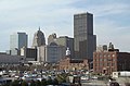
Downtown Oklahoma City

Oklahoma City Media

Map of Indian Territory (Oklahoma) 1888 from Britannica 9th ed.

Oklahoma City, Indian Territory Albert E. Downs (American, 19th century), after Thaddeus Mortimer Fowler (American, 1842–1922) Tinted lithograph, published by Thaddeus Mortimer Fowler, ca. 1890 Deák 878 41 x 75 cm. Digital Image ID: 55116

Postcard: Broadway in Oklahoma City, Oklahoma, about 1910; eBay store Web page states: "1910 postmark. / Size: 3-1/2 x 5-1/2""

Oklahoma City National Memorial at Christmas

Mid-May 2006 photograph of Oklahoma City taken from the International Space Station (ISS)

Automobile Alley in Oklahoma City

Looking up in the heart of Oklahoma City's Central Business District

Old Interstate 40 Crosstown, Oklahoma City

The Murrah Federal Building after the attack


References
- ↑ U.S. City Monikers, Tagline Guru website, accessed January 5, 2008
- ↑ 2.0 2.1 "Oklahoma City". Oklahoma History Society. Archived from the original on April 2, 2016. Retrieved April 12, 2016.
- ↑ "2019 U.S. Gazetteer Files". United States Census Bureau. Retrieved July 28, 2020.
- ↑ "QuickFacts: Oklahoma City city, Oklahoma". United States Census Bureau. Retrieved 21 August 2021.
- ↑ 5.0 5.1 "2020 Population and Housing State Data". United States Census Bureau. Retrieved 22 August 2021.
- ↑ "Zip Code Lookup". USPS. Archived from the original on November 4, 2010. Retrieved December 11, 2008.
- ↑ "US Board on Geographic Names". United States Geological Survey. October 25, 2007. Retrieved January 31, 2008.