Union Square, Manhattan
Union Square is a historic place surrounding neighborhood in Manhattan, New York City, located where Broadway and the former Bowery Road – now Fourth Avenue[4] – came together in the early 19th century.
Union Square | |
 | |
Union Square looking north from 14th Street (May 2010) | |
| Location: | Manhattan, New York City |
|---|---|
| Coordinates: | 40°44′08″N 73°59′26″W / 40.73556°N 73.99056°WCoordinates: 40°44′08″N 73°59′26″W / 40.73556°N 73.99056°W |
| Built: | 1882 (laid out c. 1832)[1] |
| Architect: | Frédéric Auguste Bartholdi, et al. |
| Governing body: | New York City Department of Parks and Recreation |
| NRHP Reference#: | 97001678 |
| Significant dates | |
| Added to NRHP: | December 9, 1997[2] |
| Designated NHL: | December 9, 1997[3] |
Union Square, Manhattan Media
W New York Union Square with the Everett Building visible on the left
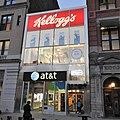
The former Kellogg's cafe at Union Square; the AT&T Wireless store is underneath it and next to the entrance.
References
- ↑ "Parks for the New Metropolis (1811–1870)". New York City Department of Parks and Recreation. Archived from the original on November 26, 2011. Retrieved March 27, 2008.
- ↑ "National Register Information System". National Register of Historic Places. National Park Service. 2007-01-23.
- ↑ "Union Square". National Historic Landmark summary listing. National Park Service. September 20, 2007. Archived from the original on October 29, 2007.
- ↑ Four Shortened – Manhattan's Shortest Numbered Avenue, Forgotten NY. Accessed January 16, 2018. "Among New York City's numbered avenues, 1st through 12th, 4th Avenue has always been the odd duck-- you can tell just by looking at a map. While most avenues are extraordinarily lengthy, spanning much of the island from north to south, 4th runs just six short blocks between Cooper and Union Squares; and while all of NYC's numbered avenues run parallel to the island's northward tilt (though not true north) 4th runs northwest athwart the other avenues, forming a 'V' at the Bowery at Cooper Square."


