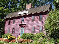
Woburn, Massachusetts
Woburn (/ˈwuːbərn/ WOO-bərn) is a city in Middlesex County, Massachusetts, United States. The population was 40,876 at the 2020 census.[2] Woburn is located 9 miles (14 km) north of Boston.
 | |
Official seal of Seal | |
|
| |
| Location in Middlesex County, Massachusetts Location in Middlesex County, Massachusetts | |
| Coordinates: 42°28′45″N 71°09′10″W / 42.47917°N 71.15278°WCoordinates: 42°28′45″N 71°09′10″W / 42.47917°N 71.15278°W | |
| Country | |
| State | |
| County | Middlesex |
| Region | New England |
| Settled | 1640 |
| Incorporated (town) | 1642 |
| Incorporated (city) | 1889 |
| Named for | Woburn, Bedfordshire |
| Government | |
| • Type | Mayor-council city |
| Area | |
| • Total | 12.94 sq mi (33.52 km2) |
| • Land | 12.65 sq mi (32.76 km2) |
| • Water | 0.29 sq mi (0.76 km2) |
| Elevation | 100 ft (30 m) |
| Population | |
| • Total | 40,876 |
| • Density | 3,231.30/sq mi (1,247.64/km2) |
| Time zone | UTC−5 (Eastern) |
| • Summer (DST) | UTC−4 (Eastern) |
| ZIP Codes | 01801, 01888 |
| FIPS code | 25-81035 |
| GNIS feature ID | 0612270 |
| Website | www.woburnma.gov |
Woburn, Massachusetts Media
- 1790 House, Woburn, Massachusetts, Sept. 2005.JPG
1790 House, Woburn, Massachusetts. Photograph taken by me, September 2005.
- Baldwin House, Woburn, Massachusetts.JPG
Baldwin House, Woburn, Massachusetts, with a stretch of the Middlesex Canal in foreground
- City hall, Woburn, Mass (67567).jpg
A postcard featuring Woburn City Hall
- OrdinationOfCarter.jpg
This painting depicts the ordination of Thomas Carter as minister of Woburn, Massachusetts in 1642. To his right is Captain Edward Johnson, the "Father of Woburn." The painting hangs in the Woburn Public Library.
Perspective map of Woburn from 1883, J. Lyth engraver
Deacon Edward Convers House, first house built in Woburn, 1640
1852 Map of Boston area showing Woburn and the Middlesex Canal
References
- ↑ "2020 U.S. Gazetteer Files". United States Census Bureau. Retrieved May 21, 2022.
- ↑ 2.0 2.1 "QuickFacts: Woburn city, Massachusetts". United States Census Bureau. Retrieved March 5, 2024.


