Alta California
Alta California ('Upper California'), also known as Nueva California ('New California') among other names,[a] was a province of New Spain formally established in 1804. Along with the Baja California peninsula, it had previously comprised the province of Las Californias, but was made a separate province in 1804 (named Nueva California).[1] Following the Mexican War of Independence, it became a territory of Mexico in April 1822[2] and was renamed Alta California in 1824.
| Alta California | |||||
| Province of the Viceroyalty of New Spain (1804–1821) Province of the First Mexican Empire (1821–1824) Federal Territory of Mexico (1824–1836) | |||||
| |||||
| Capital city | Monterey (1804–1836) | ||||
| Governor | |||||
| - | 1804–1814 | José Joaquín de Arrillaga (First Spanish governor) | |||
| - | 1815–1822 | Pablo Vicente de Solá (Last Spanish governor) | |||
| - | 1822–1825 | Luis Antonio Argüello (First Mexican governor) | |||
| - | 1836 | Nicolás Gutiérrez (Last Alta California governor) | |||
| Historical era | Spanish colonial era | ||||
| - | Las Californias | 1769 | |||
| - | Established | 1804 | |||
| - | Treaty of Córdoba | August 24, 1821 | |||
| - | Disestablished | 1836 | |||
| Today part of | United States | ||||
The territory included all of the U.S. states of California, Nevada, and Utah, and parts of Arizona, Wyoming, and Colorado. The territory was re-combined with Baja California (as a single departamento) in Mexico's 1836 Siete Leyes (Seven Laws) constitutional reform, granting it more autonomy.[3][4] That change was undone in 1846, but rendered moot by the outcome of the Mexican–American War in 1848, when most of the areas formerly comprising Alta California were ceded to the U.S. in the treaty which ended the war. In 1850, California joined the union as the 31st state.
Alta California Media
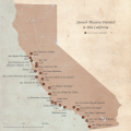
The 21 Spanish missions in Alta California (outline of the present state of California).
Mission San Carlos Borromeo de Carmelo, established in 1770, was the headquarters of the Californian mission system from 1797 until 1833.
Map of Mexico. S. Augustus Mitchell, Philadelphia, 1847. New California is depicted with a northeastern border at the meridian leading north of the Rio Grande headwaters.
References
- ↑ 1.0 1.1 Bancroft, Hubert Howe (1884). History of California. The History company. p. 68.
without any uniformity of usage, the upper country began to be known as California Septentrional, California del Norte, Nueva California, or California Superior. But gradually Alta California became more common than the others, both in private and official communications, though from the date of the separation of the provinces in 1804, Nueva California became the legal name, as did Alta California after 1824.
- ↑ Lua error in Module:Citation/CS1/Identifiers at line 630: attempt to index field 'known_free_doi_registrants_t' (a nil value).
- ↑ Robinson, William Wilcox (1979). Land in California: The Story of Mission Lands, Ranchos, Squatters, Mining Claims, Railroad Grants, Land Scrip, Homesteads. Chronicles of California, Volume 419: Management of public lands in the United States. Berkeley, CA: University of California Press. pp. 29. ISBN 0520038754. Retrieved 30 May 2016.
- ↑ Yenne, Bill (2004). The Missions of California. San Diego, CA: Thunder Bay Press. pp. 18f. ISBN 1592233198.
Further reading
- Album of Views of the Missions of California, Souvenir Publishing Company, San Francisco, Los Angeles, 1890s.
- Beebe, Rose Marie (2001). Lands of Promise and Despair: Chronicles of Early California, 1535–1846. Berkeley: Heyday Books. ISBN 1-890771-48-1
- Blomquist, L.R., A Regional Study of the Changes in Life and Institutions in the San Luis Obispo District, 1830–1850 (M.A. thesis, History Department, University of California, Berkeley, 1943). Source consulted by Ryan & Breschini (2010).
- Breschini, G.S., T. Haversat, and R.P. Hampson, A Cultural Resources Overview of the Coast and Coast-Valley Study Areas [California] (Coyote Press, Salinas, CA, 1983). Source consulted by Ryan & Breschini (2010).
- California Mission Sketches by Henry Miller, 1856 and Finding Aid to the Documents relating to Missions of the Californias : typescript, 1768–1802 at the Bancroft Library
- Fink, Augusta (1972). Monterey, The Presence of the Past. San Francisco, CA: Chronicle Books. ISBN 978-8770107204
- Howser, Huell (December 8, 2000). "Art of the Missions (110)". California Missions. Chapman University Huell Howser Archive.
- Milliken, Randall (1995). A Time of Little Choice: The Disintegration of Tribal Culture in the San Francisco Bay Area 1769–1910. Menlo Park, CA: Ballena Press Publication. ISBN 0-87919-132-5
- The Missions of California, by Eugene Leslie Smyth, Chicago: Alexander Belford & Co., 1899.
Footnotes
Other websites
- Worldstatesmen.org: Provinces of New Spain
- Alta California grants in UC Library System Calisphere
- Mexican Land Grants of Santa Clara County Archived 2016-05-22 at the Wayback Machine at the University of California, Berkeley, Earth Sciences & Map Library Archived 2016-05-22 at the Wayback Machine
- POPULATION IN ALTA CALIFORNIA:1790-1830 Archived 2024-06-24 at the Wayback Machine. CALIFORNIA STATE UNIVERSITY, NORTHRIDGE


