Colorado
Colorado is a state in the western United States. Its capital and largest city is Denver. Other large cities are Colorado Springs and Aurora. Colorado became the 38th state admitted to the union on August 1, 1876.
| State of Colorado | |
|
| |
|
| |
| Anthem: "Where the Columbines Grow" and "Rocky Mountain High"[1] | |
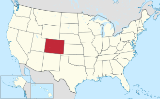
 Map of the United States with Colorado highlighted | |
| Country | United States |
| Before statehood | Colorado Territory |
| Admitted to the Union | August 1, 1876[2] (38th) |
| Capital (and largest city) | Denver |
| Largest metro | Denver |
| Government | |
| • Governor | Jared Polis (D) |
| • Lieutenant Governor | Dianne Primavera (D) |
| Legislature | General Assembly |
| • Upper house | Senate |
| • Lower house | House of Representatives |
| U.S. senators | Michael Bennet (D) John Hickenlooper (D) |
| U.S. House delegation | 5 Democrats 3 Republicans (list) |
| Area | |
| • Total | 104,094 sq mi (269,837 km2) |
| • Land | 103,718 sq mi (268,875 km2) |
| • Water | 376 sq mi (962 km2) 0.36% |
| • Rank | 8th |
| Elevation | 6,800 ft (2,070 m) |
| Highest elevation | 14,440 ft (4,401.2 m) |
| Lowest elevation | 3,317 ft (1,011 m) |
| Population (2020) | |
| • Total | 5,773,714 |
| • Rank | 21st |
| • Density | 55.46635/sq mi (21.39704/km2) |
| • Rank | 37th |
| • Median household income | $75,200[5] |
| • Income rank | 9th |
| Language | |
| • Official language | English |
| Time zone | UTC−07:00 (MST) |
| • Summer (DST) | UTC−06:00 (MDT) |
| USPS abbreviation | CO |
| ISO 3166 code | US-CO |
| Latitude | 37°N to 41°N |
| Longitude | 102°02′48″W to 109°02′48″W |
| Website | www |
| Colorado state symbols | |
|---|---|
 | |
 | |
| Living insignia | |
| Amphibian | Western tiger salamander Ambystoma mavortium |
| Bird | Lark bunting Calamospiza melanocoryus |
| Cactus | Claret cup cactus Echinocereus triglochidiatus |
| Fish | Greenback cutthroat trout Oncorhynchus clarki somias |
| Flower | Rocky Mountain columbine Aquilegia coerulea |
| Grass | Blue grama grass Bouteloua gracilis |
| Insect | Colorado Hairstreak Hypaurotis crysalus |
| Mammal | Rocky Mountain bighorn sheep Ovis canadensis |
| Pet | Colorado shelter pets Canis lupus familiaris and Felis catus |
| Reptile | Western painted turtle Chrysemys picta bellii |
| Tree | Colorado blue spruce Picea pungens |
| Inanimate insignia | |
| Colors | Blue, red, yellow, white |
| Dinosaur | Stegosaurus |
| Folk dance | Square dance Chorea quadra |
| Fossil | Stegosaurus Stegosaurus armatus |
| Gemstone | Aquamarine |
| Mineral | Rhodochrosite |
| Rock | Yule Marble |
| Ship | USS Colorado (SSN-788) |
| Slogan | Colorful Colorado |
| Soil | Seitz |
| Sport | Pack burro racing |
| Tartan | Colorado state tartan |
| State route marker | |
 | |
| Lists of United States state symbols | |
History
Native Americans first settled in Colorado. The prominent Colorado Native Americans are the Navajo, Ute, and Cheyenne-Arapahoe Indians. The state was named after the Colorado River by Spanish explorers. US Army officer and amateur explorer Zebulon Pike was recruited by the United States government in 1806 to find the source of the Mississippi River and to check out Spanish settlements in New Mexico.[6] Even though his recorded location for the source of the Mississippi was extremely inaccurate and allegedly got lost in his expedition, he did explore much of what would become the American Southwest. When he reached what is now Colorado Springs, he named a mountain after himself, Pikes Peak, which remains a symbol for the city as well as the state to this day. Colorado has a long history of mining and digging for gold. It is the place where the Pike's Peak Gold Rush took place. When gold in California was becoming harder and harder to find, people came to Colorado in large numbers when gold was discovered there in 1859, ten years after the California Gold Rush began. Many mining camps set up in Colorado would later become cities, such as Denver City and Boulder City. The motto for the gold rush was "Pike's Peak or Bust".
Geography
The State of Colorado is shaped like a rectangle. The borders are latitude and longitude lines. The four borders are at 37°N, 41°N, 102°03'W, and 109°03'W. (The east and west borders are 25°W and 32°W from the Washington Meridian.) Colorado, Wyoming, and Utah are the only three U.S. states that have only lines of latitude and longitude for boundaries and that have no natural borders. When government surveyors made the border markers for the "Territory of Colorado", minor surveying mistakes made many small kinks along the borders, most seen along the border with the "Territory of Utah."
The tip of Mount Elbert at 14,440 feet (4,401 m) elevation in Lake County is the state's highest point and the highest point in the entire Rocky Mountains. Colorado has more than 100 mountain peaks that reach over 4,000 meters (13,123 ft) in height. Colorado is the only U.S. state that lies entirely above 1,000 meters (3,281 ft) in height. Colorado has the highest average elevation of any state at 6,800 ft.[7] It borders New Mexico, Arizona, Utah, Oklahoma, Kansas, Nebraska, and Wyoming.
The land area of Colorado is roughly the same size as New Zealand.[8]
Climate
The weather and temperatures in Colorado are quite different compared to most of the United States. In most other states, the southern part is warmer than the northern part, southern Colorado is not noticeably warmer than northern Colorado. Mountains and surrounding valleys greatly affect local climate. As a normal rule, with an increase in height comes a decrease in temperature and an increase in rain. The Rocky Mountains on the west have a very different climate than the Great Plains on the east. Between these two areas is a smaller mountain range known as "the Foothills".
Population
The state's largest city, and capital, is Denver. The "Denver-Aurora-Boulder Combined Statistical Area", is home to 2,927,911 people, it has more than two-thirds of the state's population.
As of 2005, Colorado has an estimated population of 4,665,177, which is an increase of 63,356, or 1.4%, from the last year and an increase of 363,162, or 8.4%, since the year 2000. This has a natural increase since the last census of 205,321 people (that is 353,091 births minus 147,770 deaths) and an increase because of migration of 159,957 people into the state. Immigration from outside the United States makes a net increase of 112,217 people, and migration within the country made a net increase of 47,740 people.
Religion

Colorado's most common religion is Christianity, and its most common denomination is Catholicism. Colorado, and mostly the city of Colorado Springs, serves as the headquarters of many Christian groups, many of them Evangelical. "Focus on the Family" is a big conservative Christian organization headquartered in Colorado Springs.
Major religious affiliations of the people of Colorado are:
- Christian – 65%
- Protestant — 44%
- Unaffiliated – 25%
- Evangelical – 23%
- Mainline — 19%
- Roman Catholic — 19%
- Other Religions – 5%
- Jewish — 2%
- Latter Day Saint / Mormon— 2%
- Other Protestant – 2%
- Muslim — 1%
- Orthodox — 1%
Economy
The Bureau of Economic Analysis estimates that the total state product in 2007 was $236 billion. Per capita personal income in 2007 was $41,192, ranking Colorado eleventh in the United States. Early companies were based on the extraction and getting minerals and agricultural things. Today's agricultural things are cattle, wheat, dairy products, corn, and hay. On January 1 2014 Colorado became the first state to make marijuana legal.[9] In the first week of this $5 million of marijuana was sold.[10] The marijuana industry is expected to make Colorado's economy $359 million by the end of 2014.[11]
Related pages
References
| Wikimedia Commons has media related to Lua error in Module:Commons_link at line 62: attempt to index field 'wikibase' (a nil value).. |
- ↑ "Lawmakers name 'Rocky Mountain High' second state song | 9news.com". Archive.9news.com. March 13, 2006. Archived from the original on November 30, 2015. Retrieved April 1, 2016.
- ↑ President of the United States of America (August 1, 1876). "Proclamation of the Admission of Colorado to the Union" (php). The American Presidency Project. Retrieved November 15, 2018.
- ↑ "Mount Elbert". NGS data sheet. U.S. National Geodetic Survey. http://www.ngs.noaa.gov/cgi-bin/ds_mark.prl?PidBox=KL0637.
- ↑ 4.0 4.1 "Elevations and Distances in the United States". United States Geological Survey. 2001. Archived from the original on October 15, 2011. Retrieved October 21, 2011.
- ↑ "US Census Bureau QuickFacts". Retrieved April 30, 2022.
- ↑ "Pike expedition sets out". History.com.
- ↑ "50 State Elevations (mean elevation)". Netstate.com.
- ↑ "The True Size Of..."
- ↑ CNN, By Michael Martinez (December 28, 2013). "10 things to know about Colorado's recreational marijuana shops". CNN.
{{cite web}}:|last=has generic name (help) - ↑ Ferner, Matt (January 8, 2014). "Colorado Recreational Marijuana Sales Exceed $5 Million In First Week" – via Huff Post.
- ↑ Berman, Jillian (January 9, 2014). "Colorado's Weed Workers, They're Just Like Us!" – via Huff Post.


