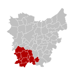
East Flanders
East Flanders [4] (Dutch: [Oost-Vlaanderen] Error: {{Lang}}: text has italic markup (help), French: [Flandre-Orientale] Error: {{Lang}}: text has italic markup (help), German: [Ostflandern] Error: {{Lang}}: text has italic markup (help)) is a province of Flanders, one of the three regions of Belgium.
|
Oost-Vlaanderen (Dutch) | |
|---|---|
Flag of Flag Coat of arms of Coat of arms | |
| Location of | |
| Coordinates: 51°00′N 03°45′E / 51.000°N 3.750°ECoordinates: 51°00′N 03°45′E / 51.000°N 3.750°E | |
| Country | |
| Region | 23x15px Flemish Region |
| Capital (and largest city) | Ghent |
| Government | |
| • Governor | Carina Van Cauter (Open Vld) |
| Area | |
| • Total | 3,007 km2 (1,161 sq mi) |
| Population (1 January 2022)[2] | |
| • Total | 1,543,865 |
| • Density | 513/km2 (1,330/sq mi) |
| HDI (2019) | 0.932[3] very high · 6th of 11 |
| Website | www |
Its capital, and also the largest city of the province, is Ghent (Dutch: [Gent] Error: {{Lang}}: text has italic markup (help), French: [Gand] Error: {{Lang}}: text has italic markup (help)).
Name
East in East Flanders means that it is in eastern part of Flanders, a region that forms part of the present Belgium. The word Flanders refers to the historic county of Flanders and appears for the first time in the year 358 under the name pagus Flandrensis[5] (pagus is a Latin word meaning a very small town, with only few houses).
The pagus Flandrensis region was a coastal area with large tidal channels and green marshes where sheep farmers lived.[5]
The modern province of East Flanders was the old Escaut department, created in 1795 during the First French Empire in the eastern part of the County[N 1] of Flanders.
In 1815, during the creation of the Kingdom of the Netherlands, the department became the province of East Flanders.
Geography
East Flanders borders (clockwise from the North) on the Netherlands and in Belgium on the provinces of Antwerp, Flemish Brabant (both in Flanders), of Hainaut (Wallonia) and of West Flanders (Flanders).
The province has an area of 3,007 square kilometres (1,161 square miles) with a population of about 1,544,000 in 2022.
The capital and biggest city is Ghent, also the second largest city in the Flemish Region. Other smaller cities are Aalst, Sint-Niklaas and Dendermonde in the east of the province.
Its highest point is Hotondberg, 150 m (492 ft) high, in the municipality of Kluisbergen, Oudenaarde district.
The main river in the province is the Scheldt (Dutch: Schelde, French: [Escaut] Error: {{Lang}}: text has italic markup (help)); it merges with the Leie in Ghent. The Dender flows into the Scheldt in the city of Dendermonde.
Administrative divisions
The province of Hainaut is divided into six arrondissements (Aalst, Dendermonde, Eeklo, Ghent, Oudenaarde and Sint-Niklaas) and a total of 60 municipalities since 2019.
(names are in the following table)
| Aalst | Dendermonde | Eeklo | |
|---|---|---|---|
170px
|
170px
|
170px | |
| Ghent | Oudenaarde | Sint-Niklaas | |
170px
|

|

|
Population by arrondissement
Population x 1,000 (on 1 January since 1980).[6]
| Arrondissement | 1970 | 1980 | 1990 | 2000 | 2010 | 2020 |
|---|---|---|---|---|---|---|
| Aalst | 265 | 263 | 258 | 262 | 274 | 294 |
| Dendermonde | 175 | 180 | 182 | 186 | 193 | 202 |
| Eeklo | 86 | 80 | 79 | 79 | 82 | 86 |
| Ghent | 472 | 486 | 486 | 495 | 527 | 564 |
| Oudenaarde | 113 | 113 | 112 | 114 | 120 | 125 |
| Sint-Niklaas | 199 | 209 | 215 | 224 | 237 | 255 |
| Province of East Flanders | 1,310 | 1,330 | 1,331 | 1,362 | 1,432 | 1,525 |
East Flanders Media
- ArrGentLocation2025.png
Locatie van het arrondissement in Oost-Vlaanderen
- ArrSint-NiklaasLocation2025.png
Locatie van het arrondissement in Oost-Vlaanderen
The Gravensteen in Ghent, the provincial capital
- Geraardsbergen - Oudeberg top 2.jpg
Notes
References
- ↑ Lua error in Module:Citation/CS1/Utilities at line 38: bad argument #1 to 'ipairs' (table expected, got nil).
- ↑ Lua error in Module:Citation/CS1/Utilities at line 38: bad argument #1 to 'ipairs' (table expected, got nil).
- ↑ Lua error in Module:Citation/CS1/Utilities at line 38: bad argument #1 to 'ipairs' (table expected, got nil).
- ↑ Official name is Provincie Oost-Vlaanderen (Dutch).
- ↑ 5.0 5.1 Lua error in Module:Citation/CS1/Utilities at line 38: bad argument #1 to 'ipairs' (table expected, got nil).
- ↑ Institut national de statistique - Direction générale Statistique et information économique
Other websites
| Wikimedia Commons has media related to Lua error in Module:Commons_link at line 62: attempt to index field 'wikibase' (a nil value).. |
| Wikivoyage has a travel guide about: East Flanders |
- Official Website (in Dutch)