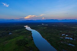
Kachin State
Kachin State (Jingpho: Wunpawng Mungdan; Burmese: ကချင်ပြည်နယ်) is a state in Myanmar. It is the northernmost state in the country. The state surrounds Hkakabo Razi, the highest mountain of Myanmar, with an elevation of 5,881 above sea level. This along with Shan State, Sagaing State, and Chin State are the only states in Myanmar with snowfall. This is also the only state in Myanmar with blizzards, and high mountains which are above 5,000 above sea level. The capital of Kachin State is Myitkyina.
|
Jinghpaw Mungdaw | |
|---|---|
Flag of Flag | |
| Location of Kachin State in Myanmar Location of Kachin State in Myanmar | |
| Coordinates: 26°0′N 97°30′E / 26.000°N 97.500°ECoordinates: 26°0′N 97°30′E / 26.000°N 97.500°E | |
| Country | |
| Region | Northern |
| Capital | Myitkyina |
| Government | |
| • Chief Minister | Khet Htein Nan |
| • Cabinet | Kachin State Government |
| • Legislature | Kachin State Hluttaw |
| • Judiciary | Kachin State High Court |
| Area | |
| • Total | 89,041.2 km2 (34,379.0 sq mi) |
| • Rank | 3rd |
| Highest elevation | 5,881 m (19,295 ft) |
| Population (2014)[1] | |
| • Total | 1,689,441 |
| • Rank | 10th |
| • Density | 18.973700/km2 (49.14166/sq mi) |
| Demographics | |
| • Ethnicities | Kachin, Lisu, Han-Chinese, Shan, Naga, Bamar, Nu, Tibetan, Burmese Gurkha |
| • Religions |
|
| Time zone | UTC+06:30 (MMT) |
| HDI (2015) | 0.596[2] medium · 2nd |
History
Kachin people was based on shifting hill agriculture. After the Sino-Burmese War, the Chinese exercised a degree of control over the present day Kachin State. During the British colonization of Myanmar, the Kachin Hills tribes autonomy was accepted by the government of the United Kingdom. The pre-independence government under Aung San reached the Panglong Aggrement with the Shan, Kachin, and Chin peoples on February 12,1947. Kachin State was formed in the same year out of the former British Burma civil districts of Bhamo and Myitkyina, together with the northern district of Puta-o. The state was officialy announced on 10 January 1948 and Mungdaw Masat Masat Manau for 3 days since January 9 to 11,1962.
Geography
Kachin State was bordered by India to the west, and China to the north and east. Most of the hills and all the mountains of Myanmar are in Kachin State. It lies north latitude between 23°27N to 28°25N latitude, 96°0 and 98°44 longhitude. The highest mountain of Myanmar, Hkakabo Razi, was also in the Kachin State.
Economy
The economy of Kachin State was agricultural. The main products of it was rice, teak, sucar cane, and opium, the minerals include gold and jade.
Population
As of 2014, Kachin State population is 1,689,441.
Religion
The dominant religion of the Kachin State in northern Myanmar is Theravada Buddhism, which is practiced by 64% of the Kachin people, followed by Christianity, Islam, Hinduism, Mahayana Buddhism, and Tibetan Buddhism.
Kachin State Media
University of Myitkyina, Kachin State
References
- ↑ Census Report. The 2014 Myanmar Population and Housing Census. Vol. 2. Naypyitaw: Ministry of Immigration and Population. May 2015. p. 17.
- ↑ "Sub-national HDI – Area Database – Global Data Lab". hdi.globaldatalab.org. Retrieved 13 September 2018.


