Komsomolsk-on-Amur
Komsomolsk-on-Amur (Russian: Комсомольск-на-Амуре, tr. Komsomolsk-na-Amure, IPA: [kəmsɐˈmolʲsk nɐɐˈmurʲə]) is a city in Khabarovsk Krai, Russia. It is on the west bank of the Amur River in the Russian Far East. It is on the Baikal-Amur Mainline, 356 kilometers (221 mi) northeast of Khabarovsk. Population: 263,906 (2010 Census);[2] 281,035 (2002 Census);[4] 315,325 (1989 Census).[5]
| Komsomolsk-on-Amur (English) Комсомольск-на-Амуре (Russian) | |
|---|---|
| - City - | |
 View of Komsomolsk-on-Amur | |
 | |
 | |
| Administrative status (as of September 2011) | |
| Country | Russia |
| Federal subject | Khabarovsk Krai |
| Administratively subordinated to | city of krai significance of Komsomolsk-na-Amure |
| Municipal status (as of June 2004) | |
| Urban okrug | Komsomolsk-na-Amure Urban Okrug |
| Head | Alexander Viktorovich Zhornik |
| Statistics | |
| Area | 325.10 km2 (125.52 sq mi)[1] |
| Population (2010 Census, preliminary) | 263,906 inhabitants[2] |
| - Rank in 2010 | 70th |
| Density | 812/km2 (2,103/sq mi)[3] |
| Time zone | VLAT (UTC+11:00) |
| Founded | 1932 |
| City status since | 1933 |
| Postal code(s) | 6810xx |
| Dialing code(s) | +7 4217 |
| Official website | |
| Komsomolsk-on-Amur on WikiCommons | |
Geography
The city and its suburbs stretch for over 30 kilometers (19 mi) along the left bank of the Amur River. The river at this point is up to 2.5 kilometers (1.6 mi) wide. Lake Khummi is southeast of the city.[6]
The distance to Khabarovsk—the administrative center (capital city) of the krai—is 356 kilometers (221 mi); to the Pacific Ocean—about 300 kilometers (190 mi). The nearest other major town is Amursk, which is about 45 kilometers (28 mi) south.
It is about 3,900 miles (6,300 km) east of Moscow. It is at the eastern end of the BAM Railway.
History


The future site of Komsomolsk-on-Amur was conquered by the Mongols in the 13th century. It became part of the Mongol Empire under the Mongol Yuan Dynasty.
19th century
It was later held by the Manchus until the area was ceded (given) to the Russian Empire in the treaty of Aigun in 1858. The village of Permskoye (Пе́рмское) was created on the later site of Komsomolsk in 1860 by migrant peasants from what is now the Perm Krai.
20th century
1930s
The government of the Russian SFSR announced plans in 1931 to build a shipyard on the Amur at the modern site of Komsomolsk. Construction began in 1932. The town was mainly built using volunteer labor from the Communist youth organization Komsomol. This is how the town received the name Komsomolsk. However, the construction of the town was helped by the use of penal labour from the prison camps in the area.[7] The suffix on Amur was added to differentiate from other towns with the same name.
1940s
By the end of the 1940s, the shipyards plus facilities for other heavy industry had been completed. The city turned into a regional center for industries such as aircraft manufacturing, metallurgy, machinery, oil refining, and shipbuilding. Currently, Komsomolsk-on-Amur is the main center for the manufacture of Sukhoi military aircraft and the Sukhoi Superjet airliner.[8] The MiG-15bis [9] and the Lisunov Li-2[10] were both built in Komsomolsk-on-Amur.
Climate
Komsomolsk-on-Amur has a humid continental climate (Köppen Dfb).
| Climate data for Komsomolsk-on-Amur | |||||||||||||
|---|---|---|---|---|---|---|---|---|---|---|---|---|---|
| Month | Jan | Feb | Mar | Apr | May | Jun | Jul | Aug | Sep | Oct | Nov | Dec | Year |
| Record high °C (°F) | 0.7 (33.3) |
0.0 (32) |
13.6 (56.5) |
23.9 (75) |
31.0 (87.8) |
33.2 (91.8) |
36.2 (97.2) |
38.0 (100.4) |
30.0 (86) |
20.5 (68.9) |
8.3 (46.9) |
1.0 (33.8) |
38.0 (100.4) |
| Average high °C (°F) | -19.6 (-3.3) |
-13.9 (7) |
-4.0 (24.8) |
7.5 (45.5) |
16.1 (61) |
22.8 (73) |
25.1 (77.2) |
23.4 (74.1) |
17.1 (62.8) |
7.4 (45.3) |
-6.4 (20.5) |
-17.2 (1) |
4.6 (40.3) |
| Daily mean °C (°F) | -24.7 (-12.5) |
-19.8 (-3.6) |
-9.5 (14.9) |
2.3 (36.1) |
10.4 (50.7) |
17.3 (63.1) |
20.3 (68.5) |
18.5 (65.3) |
11.9 (53.4) |
2.5 (36.5) |
-10.5 (13.1) |
-21.8 (-7.2) |
-0.6 (30.9) |
| Average low °C (°F) | -30.8 (-23.4) |
-27.2 (-17) |
-17.1 (1.2) |
-3.4 (25.9) |
3.7 (38.7) |
10.8 (51.4) |
15.2 (59.4) |
13.5 (56.3) |
6.4 (43.5) |
-2.9 (26.8) |
-16.1 (3) |
-27.4 (-17.3) |
-6.6 (20.1) |
| Record low °C (°F) | -47.0 (-52.6) |
-42.0 (-43.6) |
-33.9 (-29) |
-20.8 (-5.4) |
-7.5 (18.5) |
-2.2 (28) |
0.0 (32) |
-8.9 (16) |
-6.0 (21.2) |
-22.0 (-7.6) |
-34.0 (-29.2) |
-42.0 (-43.6) |
-47.0 (-52.6) |
| Precipitation mm (inches) | 30 (1.18) |
19 (0.75) |
30 (1.18) |
43 (1.69) |
63 (2.48) |
65 (2.56) |
95 (3.74) |
110 (4.33) |
74 (2.91) |
62 (2.44) |
49 (1.93) |
32 (1.26) |
672 (26.46) |
| Avg. precipitation days | 14 | 12 | 13 | 15 | 15 | 13 | 15 | 14 | 14 | 13 | 16 | 15 | 169 |
| Avg. rainy days | 0 | 0 | 1 | 7 | 14 | 13 | 15 | 14 | 14 | 8 | 1 | 0 | 87 |
| Avg. snowy days | 14 | 12 | 13 | 11 | 3 | 0 | 0 | 0 | 0 | 8 | 15 | 15 | 91 |
| Source #1: climatebase.ru[11] | |||||||||||||
| Source #2: Weatherbase[12] | |||||||||||||
Twin towns – sister cities
Notable residents
.JPG)
- Alex Chubrevich, Israeli-Russian professional basketball player for Maccabi Haifa of the Israeli Super League.
- Yuliya Chepalova, cross-country skier.
- Anatoly Dyatlov, deputy chief-engineer of the Chernobyl Nuclear Power Plant
- Yury Gazinsky, footballer, scorer of the first goal at the 2018 FIFA World Cup, was born in the city
- Alexandra Ivanovskaya, "Miss Russia 2005"
- Valentina Khetagurova (1914–1992), founder of the Khetagurovite Campaign
- Pasha Kovalev, professional dancer
- Sergei Plotnikov, ice hockey player with Pittsburgh Penguins, NHL
- Ivan Shtyl, sprint canoer
Komsomolsk-on-Amur Media

A street in Komsomolsk-on-Amur

"House with a spire" -unofficial symbol of Komsomolsk-on-Amur

Hapoel Eilat vs. Maccabi Haifa B.C., 25 September, 2015
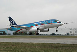
Test flight of a Sukhoi Superjet 100 prototype in Komsomolsk-on-Amur

Tram RVZ-6 in Komsomolsk-on-Amur


.JPG)


References
- ↑ "Результат запроса". www.gks.ru. Archived from the original on December 24, 2013. Retrieved November 1, 2017.
- ↑ 2.0 2.1 "Всероссийская перепись населения 2010 года. Том 1[[Category:Articles containing Russian-language text]][[Category:Lang and lang-xx using deprecated ISO 639 codes|ru]]". Всероссийская перепись населения 2010 года (2010 All-Russia Population Census) (in Russian). Federal State Statistics Service. 2011. Retrieved June 29, 2012.
{{cite web}}: Check date values in:|accessdate=(help); no-break space character in|accessdate=at position 9 (help); Unknown parameter|trans_title=ignored (|trans-title=suggested) (help); URL–wikilink conflict (help)CS1 maint: unrecognized language (link) - ↑ The value of density was calculated automatically by dividing the 2010 Census population by the area specified in the infobox. Please note that this value may not be accurate as the area specified in the infobox does not necessarily correspond to the area of the entity proper or is reported for the same year as the population.
- ↑ "Численность населения России, субъектов Российской Федерации в составе федеральных округов, районов, городских поселений, сельских населённых пунктов – районных центров и сельских населённых пунктов с населением 3 тысячи и более человек[[Category:Articles containing Russian-language text]][[Category:Lang and lang-xx using deprecated ISO 639 codes|ru]]". Всероссийская перепись населения 2002 года (All-Russia Population Census of 2002) (in Russian). Federal State Statistics Service. May 21, 2004. Retrieved February 9, 2012.
{{cite web}}: Check date values in:|accessdate=(help); no-break space character in|accessdate=at position 9 (help); Unknown parameter|trans_title=ignored (|trans-title=suggested) (help); URL–wikilink conflict (help)CS1 maint: unrecognized language (link) - ↑ Demoscope Weekly (1989). "Всесоюзная перепись населения 1989 г. Численность наличного населения союзных и автономных республик, автономных областей и округов, краёв, областей, районов, городских поселений и сёл-райцентров.[[Category:Articles containing Russian-language text]][[Category:Lang and lang-xx using deprecated ISO 639 codes|ru]]". Всесоюзная перепись населения 1989 года (All-Union Population Census of 1989) (in Russian). Institute of Demographics of the State University—Higher School of Economics. Retrieved February 9, 2012.
{{cite web}}: Check date values in:|accessdate=(help); no-break space character in|accessdate=at position 9 (help); Unknown parameter|trans_title=ignored (|trans-title=suggested) (help); URL–wikilink conflict (help)CS1 maint: unrecognized language (link) - ↑ Google Earth
- ↑ Aleksander Solzhenitsyn, The Gulag Archipelago: 1918-1956, 592-593
- ↑ "Team.Aero - Sukhoi Rolls Out Superjet 100 in Aeroflot Livery". Team.Aero. Archived from the original on November 7, 2017. Retrieved November 1, 2017.
- ↑ "What was the yearly number of MiG-15's produced?". aviation.stackexchange.com. Retrieved November 1, 2017.
- ↑ http://www.oldwings.nl/st/li2.pdf[bare URL PDF]
- ↑ "climatebase.ru (1948-2011)". Retrieved April 28, 2012.
- ↑ "Weatherbase: Historical Weather for Komsomolsk-on-Amur, Russia". Weatherbase. 2012. Retrieved on November 24, 2011.
- ↑ "Города-побратимы". kmscity.ru (in русский). Komsomolsk-on-Amur. Retrieved 2020-02-04.
Other websites
| Wikivoyage has a travel guide about: Komsomolsk-on-Amur |
- Sports in Komsomolsk-on-Amur
- FC Smena (Komsomolsk-on-Amur) Archived July 29, 2019, at the Wayback Machine