Pyrenees
The Pyrenees (Catalan: [Pirineus] Error: {{Lang}}: text has italic markup (help); Spanish: Pirineos, French: [Pyrénées] Error: {{Lang}}: text has italic markup (help); Occitan: [Pirenèus] Error: {{Lang}}: text has italic markup (help); Aragonese: [Perinés] Error: {{Lang}}: text has italic markup (help); Basque: [Pirinioak] Error: {{Lang}}: text has italic markup (help)) are a range of mountains in southwest Europe that form a natural border between France and Spain. They separate the Iberian Peninsula from France, and extend for about 430 km (267 mi) from the Atlantic Ocean (Bay of Biscay) to the Mediterranean Sea (Cap de Creus).
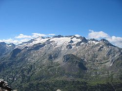
| 280px Central Pyrenees seen from the summit of the Pic du Midi de Bigorre | |
| Elevation | 3,404 m (11,168 ft) |
|---|---|
| Location | |
| Geology | |
| Age of rock | |
Pyrenees Media
Composite satellite image of the Pyrenees (NASA)
Pico de Aneto, the highest mountain of the Pyrenees, Aragon (Spain)
- Pic de Bugatet.jpg
Pic de Bugatet in the Néouvielle massif
- Pedraforca.jpg
Pedraforca, Catalonia (Spain)
- Baretous piemont Pyreneen.jpg
Baretous Valley and Piedmont plain, in the French western Pyrénées
- Gavarnie-Cirque.JPG
Cirque de Gavarnie with its 422 metre high waterfall, Occitanie (France)
- San Mauricio lake.jpg
Sant Maurici lake in the Aigüestortes i Estany de Sant Maurici National Park, Catalonia (Spain)
- Monteperdido y Cilindro.jpg
Monte Perdido, Aragon (Spain)
- Ibón.JPG
Ibón (glacial lake) Basa Mora, in Gistain valley, Aragon.
Other websites
| 40x40px | Wikimedia Commons has media related to Lua error in Module:Commons_link at line 62: attempt to index field 'wikibase' (a nil value).. |
- Great Routes: Pirineos Archived 2012-12-18 at Archive.today, from a website of the Instituto de Turismo de España
- Official website Archived 2006-03-05 at the Wayback Machine of France's Pyrenees National Park
- Cycling the French High Pyrenees and Ariege Pyrenees photos and video by steephill.tv bike travelogue
- The Aude and Pyrénées-Orientales Online resource for the Aude & Pyrénées-Orientales departments of the Languedoc-Roussillon.
