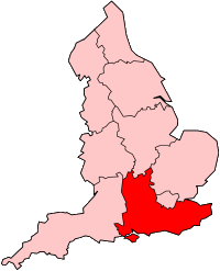
South East England
South East England is one of the nine official regions of England. It was created in 1994. It includes Berkshire, Buckinghamshire, East Sussex, Hampshire, Isle of Wight, Kent, Oxfordshire, Surrey and West Sussex.
Its population as of the 2001 census was 8,000,550, making it the most populous English region. The highest point is Walbury Hill in Berkshire at 297m/974 ft. The major urban areas of the region include Brighton and Hove, Portsmouth, Southampton, and Reading. Settlements closer to London are part of the Greater London Urban Area.
Local government
The official region consists of the following subdivisions:
| Ceremonial county | County/ unitary | Districts |
|---|---|---|
| Berkshire | West Berkshire | |
| Reading | ||
| Wokingham | ||
| Bracknell Forest | ||
| Windsor and Maidenhead | ||
| Slough | ||
| Buckinghamshire | Buckinghamshire | South Bucks, Chiltern, Wycombe, Aylesbury Vale |
| Milton Keynes | ||
| East Sussex | East Sussex | Hastings, Rother, Wealden, Eastbourne, Lewes |
| Brighton & Hove | ||
| Hampshire | Hampshire | Gosport, Fareham, Winchester, Havant, East Hampshire, Hart, Rushmoor, Basingstoke and Deane, Test Valley, Eastleigh, New Forest |
| Southampton | ||
| Portsmouth | ||
| Isle of Wight | ||
| Kent | Kent | Dartford, Gravesham, Sevenoaks, Tonbridge and Malling, Tunbridge Wells, Maidstone, Swale, Ashford, Shepway, Canterbury, Dover, Thanet |
| Medway | ||
| Oxfordshire | Oxford, Cherwell, South Oxfordshire, Vale of White Horse, West Oxfordshire | |
| Surrey | Spelthorne, Runnymede, Surrey Heath, Woking, Elmbridge, Guildford, Waverley, Mole Valley, Epsom and Ewell, Reigate and Banstead, Tandridge | |
| West Sussex | Worthing, Arun, Chichester, Horsham, Crawley, Mid Sussex, Adur | |
South East England Media
Harwell Science and Innovation Campus seen from the air in September 2015; the JANET academic computer network is headquartered there.
BritNed connects from the Isle of Grain in Medway to the TenneT network in the Netherlands.
England population density and low elevation coastal zones. South East England is particularly vulnerable to sea level rise.
The Litlington White Horse situated in the South Downs
Other websites
- South East England Development Agency Archived 2006-07-05 at the Wayback Machine - Abolished in 2012 [1]
- Tourism Information - Visit South East England


