St. Clair River
Error creating thumbnail:
Great Lakes freighters navigating on the lower St. Clair River. View is from the U.S. side, looking across to Canada.
The St. Clair River (French: [Rivière Sainte-Claire] Error: {{Lang}}: text has italic markup (help)) is a 40.5-mile-long (65.2 km)[1] river in central North America flows from Lake Huron into Lake St. Clair. It forms part of the international boundary between the Canadian province of Ontario and the U.S. state of Michigan.
St. Clair River Media
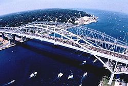
Head of river looking into Lake Huron, showing the twin Blue Water Bridge
- Algorail in (St Clair River Mich).jpg
Canadian freighter Algorail downbound in the St. Clair River
References
- ↑ U.S. Geological Survey. National Hydrography Dataset high-resolution flowline data. The National Map Archived 2017-08-23 at the Wayback Machine, accessed November 7, 2011
