Thiruvananthapuram district
Thiruvananthapuram District is the southernmost district of the coastal state of Kerala. It is the largest city in Kerala. It came into existence in the year 1957. The headquarters is the city of Thiruvananthapuram (Trivandrum) which is also the capital city of Kerala.[1]
The district has an area of 2,192 square kilometres (846 sq mi) and a population of 3,307,284 (as per the 2011 census),[2] the second-most populous district in Kerala after Malappuram district.[3] It is the densest district in Kerala with 1,509 inhabitants per square kilometre (3,910/sq mi).[4] It is divided into six taluks: Thiruvananthapuram, Chirayinkeezhu, Neyyattinkara, Nedumangadu, Varkala and Kattakada. The urban bodies in the district are the Thiruvananthapuram Corporation, Varkala, Neyyattinkara, Attingal and Nedumangad municipalities.[5]
Demographics
According to the 2011 census Thiruvananthapuram district has a population of 3,307,284,[3] roughly equal to the nation of Uruguay[6] or the US state of Connecticut.[7] This gives it a ranking of 103rd in India (out of a total of 640 districts).[3] The district has a population density of 1,509 inhabitants per square kilometre (3,910/sq mi).[3] Its population growth rate over the decade 2001–2011 was 2.25%.[3] Thiruvananthapuram has a sex ratio of 1088 females for every 1000 males,[3] and a literacy rate of 92.66%.[3]
Thiruvananthapuram District Media
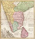
A map of Malabar Coast drawn by Homann Heirs in 1733. At that time, Travancore was only a small territory wedged between Kollam and Kanyakumari, as shown in the map (Present-day districts of Trivandrum and Kanyakumari only).
A map of the British Princely state of Travancore published in 1871
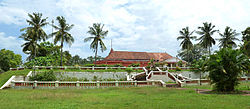
Birthplace of Raja Ravi Varma with his studio in the foreground
A Technopark building. Technopark as of 2010 has 450,000 m2 (4,800,000 sq ft) of built-up space, and is home to over 200 companies, employing around 30,000 professionals.
A highway at Akkulam in Thiruvananthapuram
References
- ↑ [1] Archived 8 March 2010 at the Wayback Machine
- ↑ "CENSUS OF INDIA 2011" (PDF). PROVISIONAL POPULATION TOTALS INDIA, KERALA STATE AND DISTRICTS. Government of India. Retrieved 24 April 2011.
- ↑ 3.0 3.1 3.2 3.3 3.4 3.5 3.6 "District Census 2011". Census2011.co.in. 2011. Retrieved 24 October 2013.
- ↑ "CENSUS OF INDIA 2011" (PDF). Provisional Population Totals Kerala. Government of India. p. 45. Retrieved 24 April 2011.
- ↑ "Districts Thiruvananthapuram". indiastudychannel. Archived from the original on 10 September 2010. Retrieved 21 July 2010.
- ↑ US Directorate of Intelligence. "Country Comparison:Population". Archived from the original on 27 September 2011. Retrieved 1 October 2011.
Uruguay 3,308,535 July 2011 est.
- ↑ "2010 Resident Population Data". U.S. Census Bureau. Archived from the original on 23 August 2011. Retrieved 30 September 2011.
Connecticut 3,574,097
1city.in Archived 2016-02-13 at the Wayback Machine
Further reading
- Manorama Yearbook 1995 (Malayalam Edition) ISSN 0970-9096.
- Manorama Yearbook 2003 (English Edition) ISBN 81-900461-8-7.
Other websites
| Wikimedia Commons has media related to Lua error in Module:Commons_link at line 62: attempt to index field 'wikibase' (a nil value).. |
- Official District website Archived 2019-08-15 at the Wayback Machine
- Government of Kerala Website on Thiruvananthapuram District Archived 2005-11-09 at the Wayback Machine


