Transport in Poland
Transport in Poland involves air, water, road and rail transportation. The country has a large network of public transport, such as buses, trams and the metro.
Water
The country's most important waterway is the Vistula river. The largest seaports are Gdańsk, Gdynia and Szczecin. There are 3,997 km (2,480 mi) of navigable rivers and canals (as of 2009).
Air transport


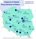
The most important airport in Poland is Warsaw 'Frederic Chopin' International Airport. Warsaw's airport is the main international hub for LOT Polish Airlines.
In addition to Warsaw Chopin, Wrocław, Gdańsk, Katowice, Kraków and Poznań all have international airports.
Rail transport


Poland has a network of railways.. It is run by Polish State Railways. The rail network is very dense in western and northern Poland. The eastern part of the country has fewer railways. The capital city, Warsaw, has the country's only rapid transit system: the Warsaw Metro.
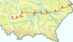
The only high-speed rail line in central-eastern Europe is the Central Rail Line,. It is 223 km (139 mi) long, and was built in 1971–1977. It links Warsaw with Kraków and Katowice.
Other high-speed lines:
- The Warsaw-Gdańsk-Gdynia railway route is undergoing a major upgrading costing $3 billion, partly funded by the European Investment Bank, including track replacement, realignment of curves and relocation of sections of track to allow speeds up to 200 km/h (124 mph), modernization of stations, and installation of the most modern ETCS signalling system, which is to be completed in June 2015.
- Warsaw–Kutno–Poznań–(Berlin) (160 km/h)
- Warsaw–Siedlce–Terespol–(Minsk) (160, 120 km/h) – being upgraded to 160 km/h
- Warsaw–Puławy–Lublin (120, 140 km/h)
- Opole–Wrocław (160 km/h) and further upgraded via Legnica to Berlin and Hamburg
Road transport


Poland has 424,563 km (263,810 mi) of public roads, of which 120,563 km (74,910 mi) are unsurfaced (2021):[1]
- National roads (Technical classes A, S, GP and exceptionally G): 19,403 km (12,060 mi), 1.9 km (1 mi) unsurfaced
- Voivodeship roads (Classes G, Z and exceptionally GP): 28,924 km (17,970 mi), 63.2 km (39 mi) unsurfaced
- Powiat roads (Classes G, Z and exceptionally L): 124,572 km (77,410 mi), 11,379 km (7,070 mi) unsurfaced
- Gmina roads (Classes L, D and exceptionally Z): 251,664 km (156,380 mi), 120,419 km (74,820 mi) unsurfaced
In recent years, the network has been improving and government spending on road construction recently saw a huge increase, due to rapid development of the country and the inflow of European Union funds for infrastructure projects.[2]
Motorways and expressways
Polish motorways and expressways are part of the national roads network. As of December 2021, there are 1,721 kilometres (1,070 mi) of motorways and 2,790 km (1,730 mi) of expressways .[3]
Transport In Poland Media
A1, A4 motorways and national road 44 junction near Gliwice
A2 near Poznań, opened in 2003
Semi-trailer truck average daily traffic in 2015
References
- ↑ "Rodzaje dróg w Polsce - Ministerstwo Infrastruktury - Portal Gov.pl". Ministerstwo Infrastruktury (in polski). Retrieved 2021-08-21.
- ↑ "Adisa Banjanovic, Improving Poland's transport infrastructure".
- ↑ "Generalna Dyrekcja Dróg Krajowych i Autostrad - Generalna Dyrekcja Dróg Krajowych i Autostrad - Portal Gov.pl".


